The Legislature’s House and Senate Redistricting Committees get to work today drawing the district maps that will serve their partisan interests for the next ten years. Our map-drawing legislators have in their hands data similar to what I produced from the August Census release showing which existing districts have lost population, which have gained, and how much. No statute binds legislators to preserve existing legislative districts; they could start with the existing map and noodle around adding Census blocks to or subtracting blocks from standing districts, but they might find it just as easy to start with a blank map and draw entirely new districts based on current population.
That’s the approach I have taken with District Builder, a free tool recommended by reader Richard Schriever. Create a free account, pick your state, punch in the number of districts you want (South Dakota has 35 Senate districts, but Article 3 Section 2 allows us to reduce that as far as 25), and start mapping!
I have spent countless joyful hours over the last couple weeks clicking all over South Dakota, trying to create districts close to the target population of 25,333 while keeping districts contiguous and compact. (Math, geography, politics—how could I not lose track of time?!) The best map I’ve been able to generate so far is this one, in which I get population variance below 3% in either direction (lowest population is 24,597—736 low in my new and admittedly ugly District 11 in central South Dakota based around Pierre; highest is 25,931—598 high in my new District 34, based around Lake and Moody). That’s tighter than the 5% bound high and low that I understand federal law requires. As you’ll see, my map pays zero attention to concentrations of Republican and Democratic voters. It also starts with a commitment to take advantage of splitting cities up to balance population: the more town population one can pull into a district, the less a district has to sprawl to take in enough sparse rural counties to reach the 25,333 population target.
Take a look at my current draft, and let the shouting begin:
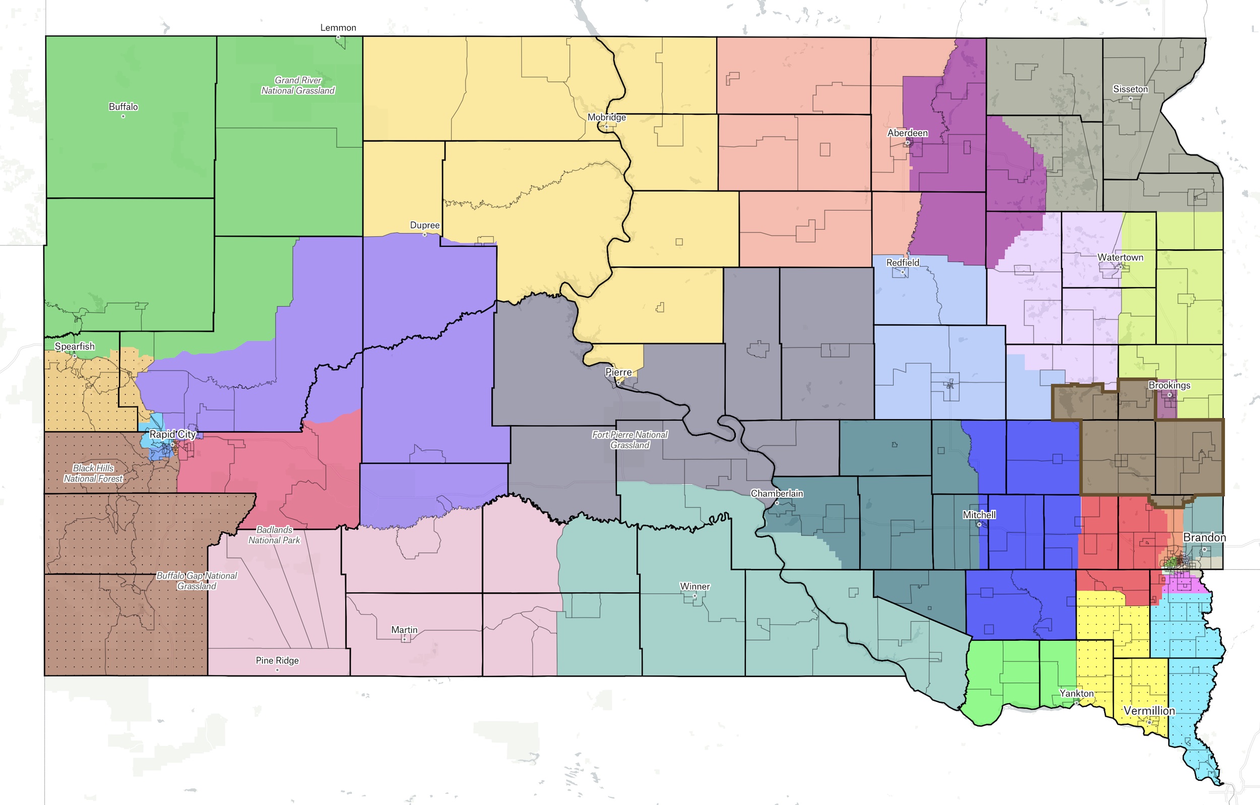
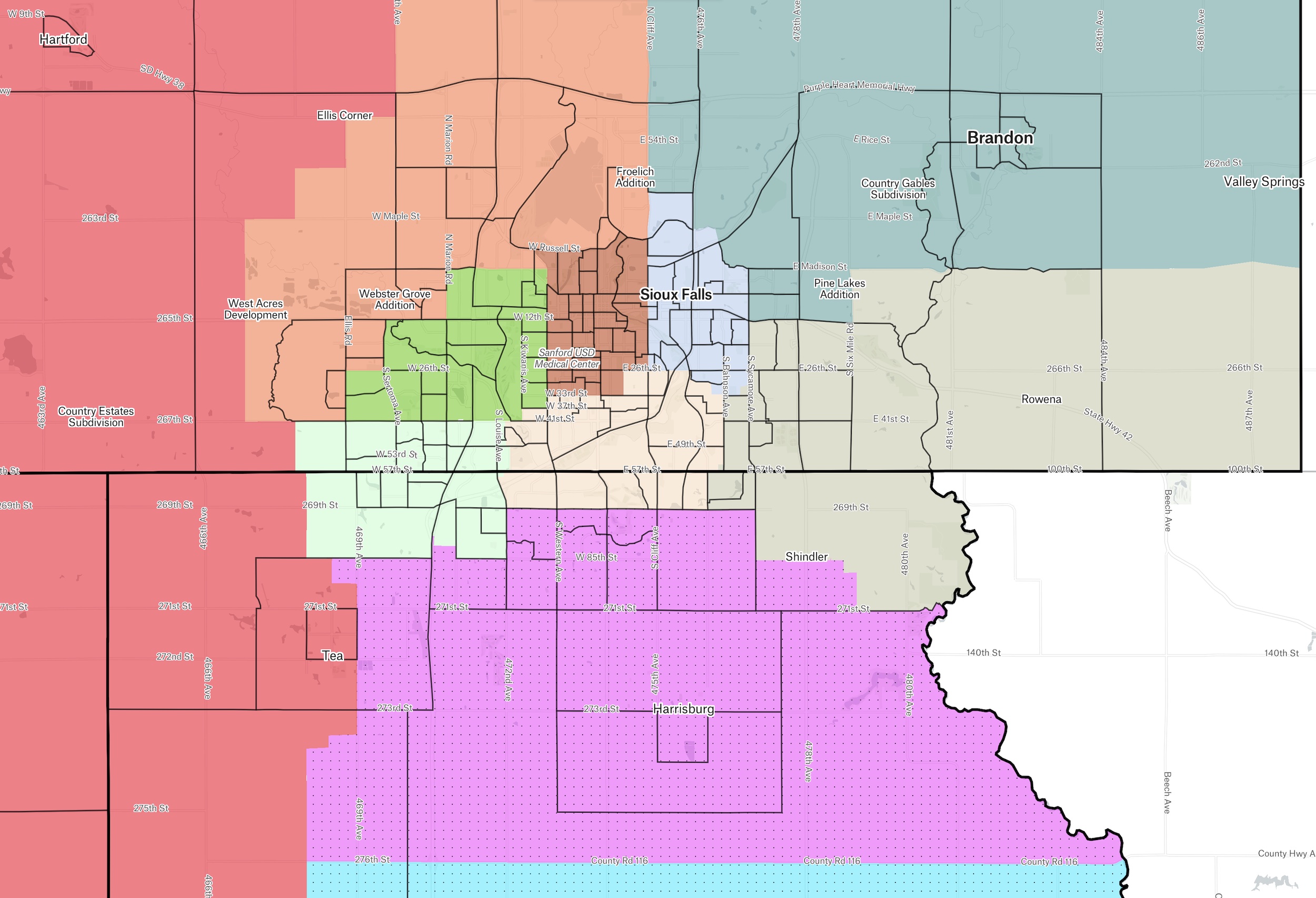
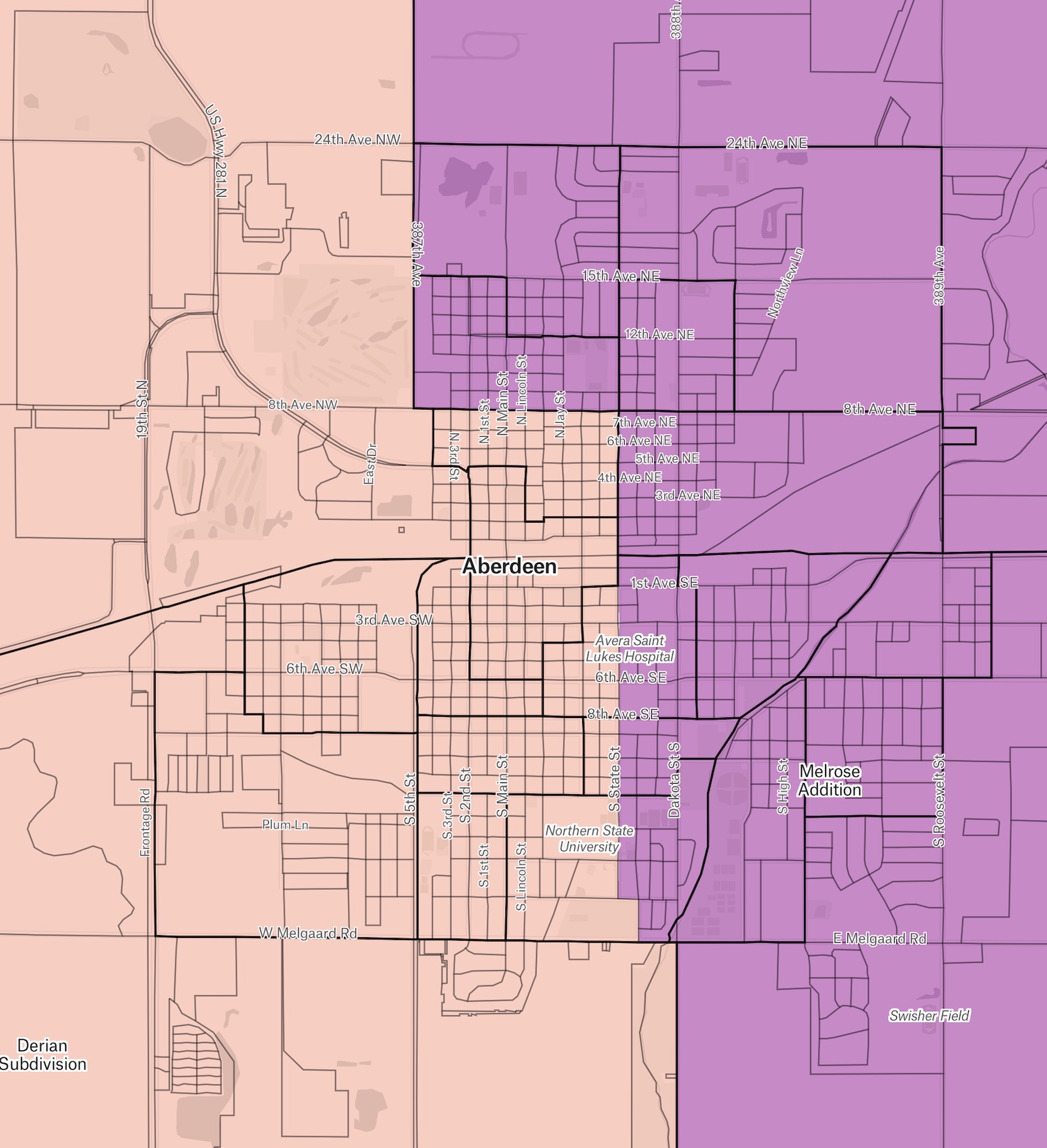
Sioux Falls, Rapid City, and Aberdeen all have to be split up:

But in an improvement over the current map, I manage to split the Aberdeen area into just two districts instead of three:
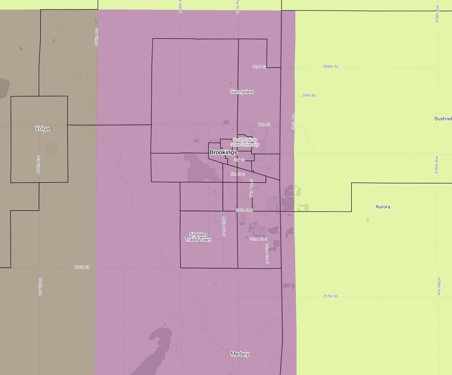
I manage to keep Brookings mostly together in a nice neat rectangle:
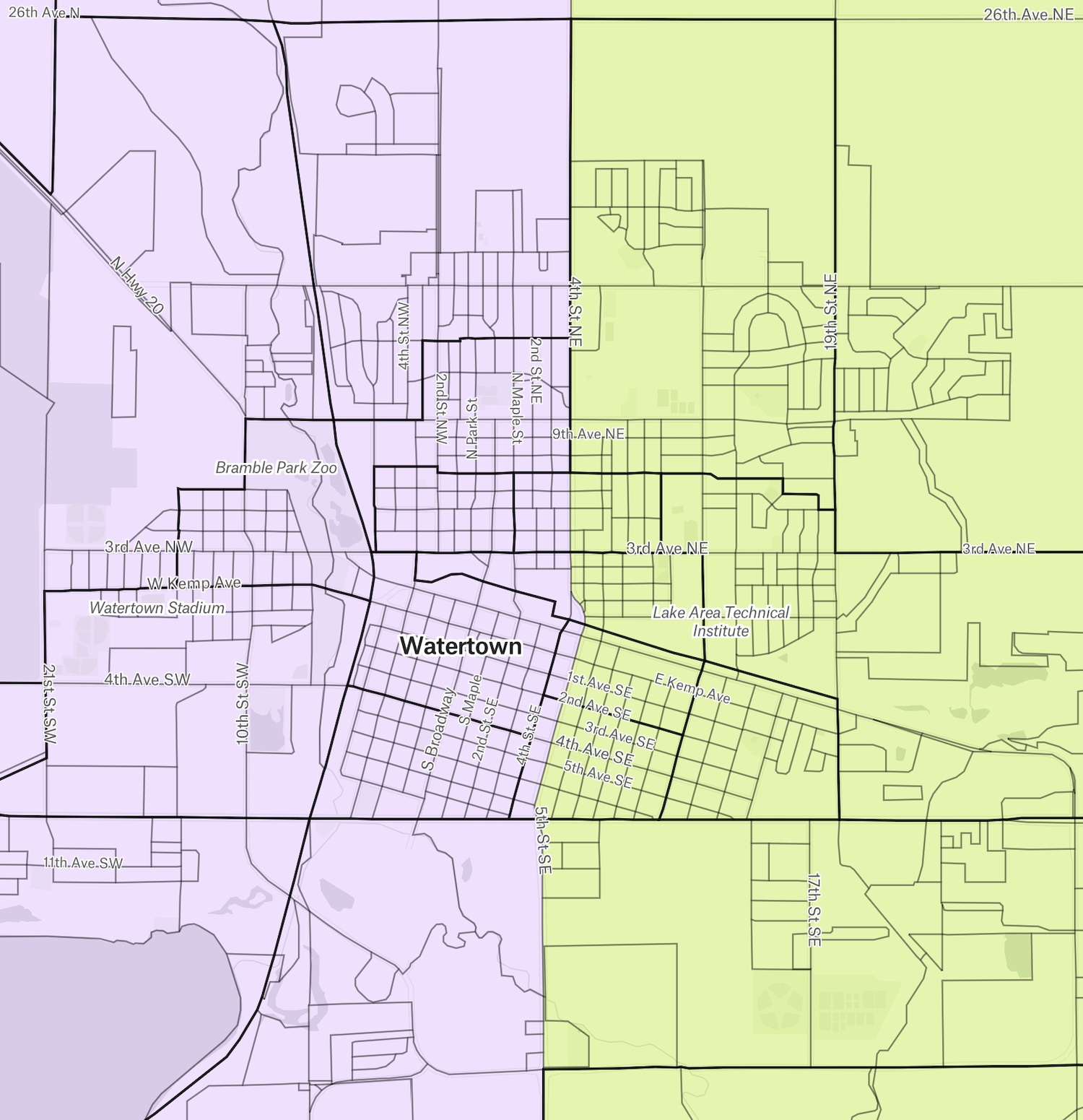
But inspired by Senator Lee Schoenbeck’s (R-5/Watertown) clarion call to end the mad gerrymander of District 2, I follow his example and split Watertown east-west along 4th Street Northeast and 5th Street Southeast:
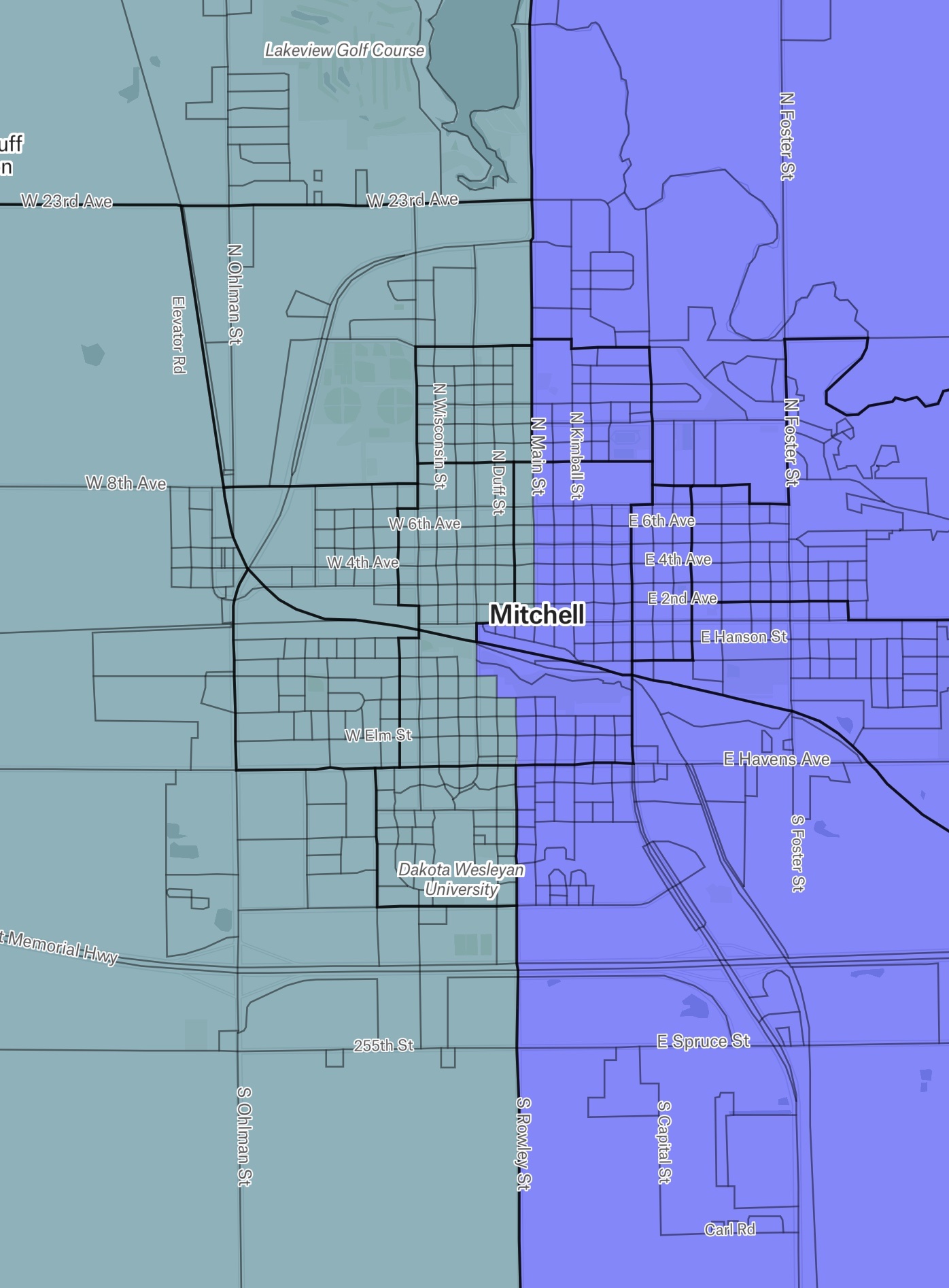
I also take the east-west axe to Mitchell to reduce the square-mileage of its adjoining districts:
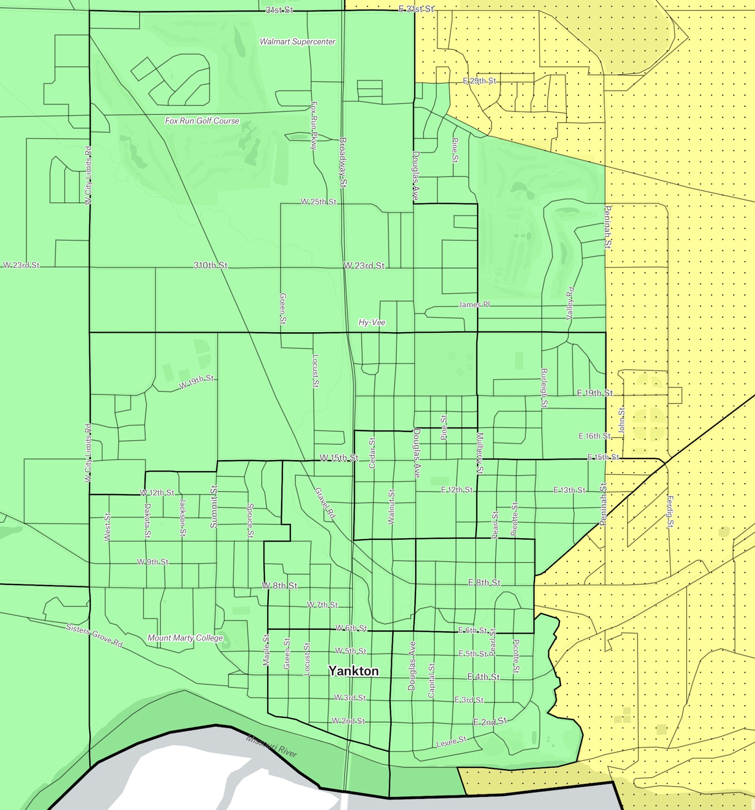
I also split Yankton, sending its eastern edge along with the eastern half of Yankton County to the Vermillion–Viborg district while joining most of the city and the western half of the county to Bon Homme County. That split avoids dragging Bon Homme into already sprawling districts to the north and west; it also allows me to use the northern portion of Turner County to create a reasonably compact district with eastern McCook and western Minnehaha.
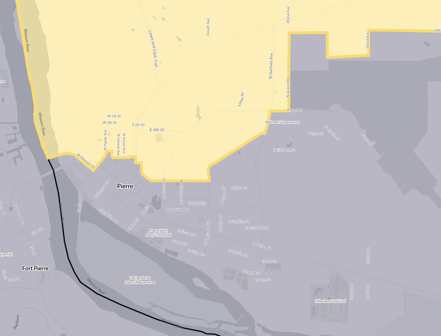
Huron stays intact and pulls Redfield and DeSmet into its new district. But to avoid drawing one massive district for northwestern South Dakota that would require representatives to drive from Mobridge to Bell Fourche to speak to all of their constituents, I let my north central district reach down from Mobridge into Pierre, and I let my northwest district reach down from Belle Fourche into Spearfish:

I don’t particularly like splitting towns that have populations under the total district population and thus could be kept integral within more compact districts. An argument can be made that dividing large towns to keep rural districts somewhat more compact only ensures a larger number of big-town legislators who will vote toward big-town interests over country interests in Pierre. But given that our ten largest counties with their big towns account for 64% of our population, not to mention 95% of our population growth, there’s also an argument that our big towns deserve the lion’s share of seats in the chambers. And if more representatives do come from the towns we split to reduce the physical size of districts, then more representatives will be within closer driving distance of more of their constituents, which should make more representatives more accessible to their constituents.
But hey, my maps here are just one draft. District Builder makes it easy for any of you to try your hand at redistricting and experience the challenges our legislators face in producing reasonable, non-sprawly districts. Take your best shot, and see if you can come up with better maps for the Legislature of the 2020s!
How are 66 county seats and their bureaucracies either conservative or sustainable? They’re not; but, it is the way Republican cronyism and patronage built barricades to democracy by providing benefits of the public dole to those who say they deplore big gubmint in a state that hates poor people.
Voter turnout is dismal in Indian Country mostly because tribal nations endure hopelessness as they compete with the stingy red moocher state government for resources.
The Wanblee district should be in Oglala Lakota County then Jackson should be rolled into Haakon. Stanley, Jones and Lyman Counties should be one. Sully should be rolled into Hughes. Give Indian Country some clout by making Oglala Lakota, Mellette, Bennett, Todd, Gregory and Tripp one county. Dewey, Ziebach and Corson should be a county. Butte, Harding and Perkins should be one. Lawrence and Meade should be one, Fall River and Custer should be one.
Combine Marshall and Brown Counties, too. East River is a dead zone: smarter people than i can figure out how to sort out that mess. Everything east of the Missouri River is Cleveland anyway.
Your Rapid City map isn’t much of an improvement.
Your proposed map is interesting. It makes Jean Hunhoff s proposed residence move to Tabor an even stronger possibility………………
Love the call to action by the folks. Get involved. Make some mistakes. Learn. Contribute. Communicate.
Donald, I wondered about that. District Builder does provide racial and party information for each block, so one can use District Builder to try to pack or crack minority and partisan clusters. However, I’ve mostly ignored those figures so far and have focused on the target population and geography. I’m working on a map that minimizes city splits right now; then I may turn to a map that tries to optimize Democratic outcomes (ha!) and tries to protect minority representation.
Frank, so far, I have completely ignored where incumbents and potential candidates live. Which district did I put you in?
Curious, Donald: can you recommend some neighborhood lines I could follow that would improve the RC districts?
One issue you allude to in the comments but didn’t address in your map is minority representation. If minorities, and in South Dakota that means Native Americans, are unable to get a fair shot at electing legislators expect a federal court challenge and maps redrawn by some federal district judge. That is unless the US Supreme Court has reinterpreted election law to the point that minority representation is no longer a valid concern.
Wow Cory, jerrymandering for everyone. You forgot to check out the party the way the trumpies do. They know they need to have at least a few almost total Democratic areas so they have divide and conquer in the rest. Nobody in Risk tries to hold Russia right away. It’s South America or Australia and you still need good dice.
“ The laws the state legislatures are passing are lethal to every Native American living in those states,” said OJ Semans, the founder of the Native voting rights group Four Directions and an enrolled member of the Rosebud Sioux Tribe in South Dakota. Such legislation, he said, “is going to knock us back 10 years” after “what we’ve been working through for the last 18 to 20 years to get more and more Native Americans to participate in elections.”
https://www.huffpost.com/entry/native-american-voting-rights_n_6116d0f7e4b07c140314ed7a
grudznick again agrees with his close personal friend, Lar. We need to cut down the number of districts to the minimum allowable. But good work, Mr. H, for a first draft. I am a little leery of having more big city representation in the legislatures by splitting a bunch of those medium sized towns like that, but I enjoyed your mappings.
well…good go at it Cory…creates some interesting districts …The Belle-Spearfish district makes sense to me as does putting the Orman irrigation district in with Sturgis …..the maps a little messy in the central with Pierre gerrymandered in with the counties north and a sprawling district going Pan Missouri stretching from Murdo to Miller with both the Crow Creek and Lower Brule included in the district. I find splitting Aberdeen, Mitchell, and Yankton in two interesting and defensible…all those cities consider themselves “hubs” or “trade centers” for farm areas to the west and east…you may create “rural-urban “votes rather than party line voting.
Should add that lumping Pierre in with the Cheyenne and Standing Rock reservations may end up being poetic justice…Pierre might serve as a trade city for Lower Brule and Crow Creek but I’ve rarely run into folks from Eagle Butte or Wakpala in Pierre. Maybe at the Ft. Pierre sales barn or rodeo but not in downtown Pierre.
Being a Rapid City native and a demographics/mapping nerd (also part of my work), your proposal gives Rapid a swing/leans D district (the orange one centered on downtown).
The census tract I grew up in – the north-south rectangle just SW of downtown – is the only one Hillary carried and on of about a half-dozen Joe B. carried. In this proposal it gets swept in with the affluent, mostly-red districts in SW Rapid. Oh well. :) Good work.
Joe: interesting! District Builder tells me that the orange district I drew over downtown RC actually leans GOP by 18 points, same as the darker blue district to its west. My brown Madison-Flandreau district also weighs in at R+18. Only thirteen other districts offer lower GOP advantages. Out of those 13, my Pine Ridge district is the only one where Dems have an advantage (D+18); my downtown Sioux Falls district is an even split.