Navigator CO2 has decided we are smart enough after all to look at their maps of where the carbon dioxide from their proposed Heartland Greenway pipeline might leak. After trying to keep the maps secret to avoid public misunderstanding, Navigator officials said sure, fine, let people see our plume modeling maps, and the Public Utilities Commission obliged.
And it turns out the plume-modeling map really isn’t that complicated. Just draw the pipeline, then draw a purple zone 1,855 feet on either side of the pipeline. That purple zone is the “maximum dispersion zone” where 30 minutes of exposure to a 4% concentration of carbon dioxide could knock you and your car out.
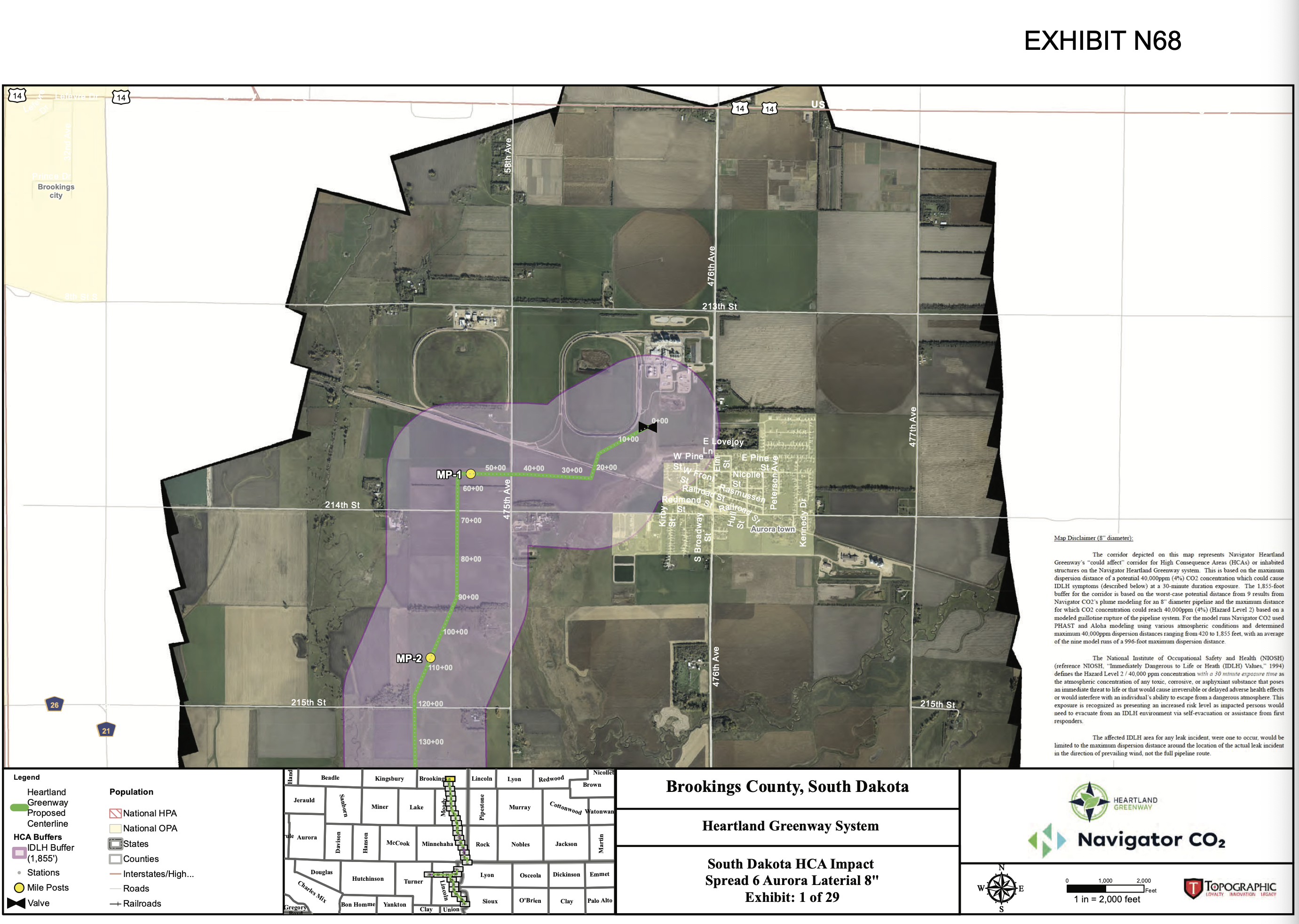
So as you can see, if the pipeline blows a gasket at the Valero plant, most of Aurora won’t pass out.
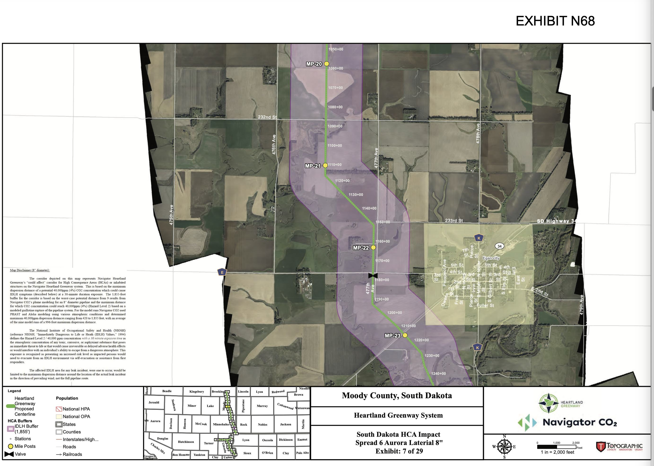
Egan, too, appears to be safe—as safe as Egan can be on any given day.
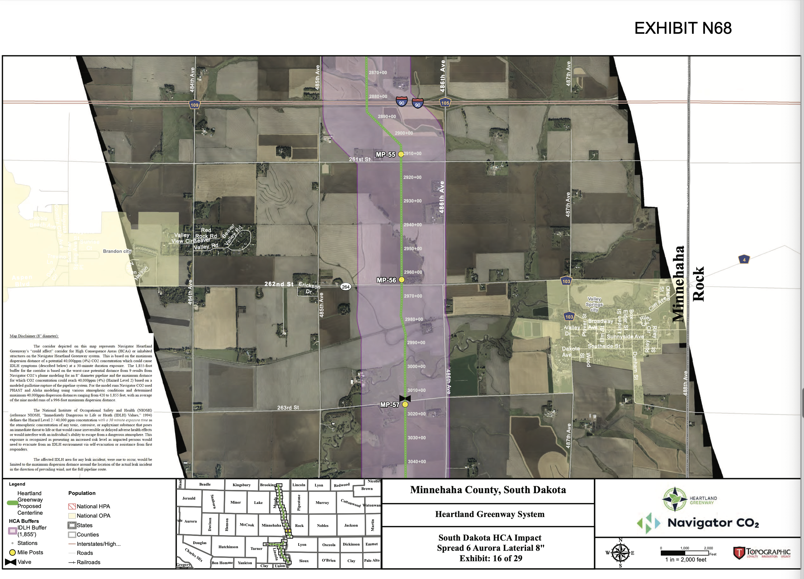
I do wonder: if Navigator’s pipeline springs a leak under I-90, will the carbon dioxide concentration shut down the cars zooming east to Minnesota for tax-free groceries? Would woozy eastbound drivers still be able to coast to the fresh air at the Valley Springs exit? I don’t know the answer for sure, but now that we have this map with its estimated not-quite-three-quarter-mile carbon-dioxide risk zone, we can look for potential trouble spots like the I-90 crossing, ask what impacts leaks may have on health and commerce at certain points along the pipeline, and get answers from the good scientists at Navigator.
What is the co2 concentration in the purple zones? If you can hold your breath for about a minute while coasting through the i90 crossing you might be ok.
To me eminent domain by private companies is the main issue. Safety is obvi important but risks can me mitigated to within an acceptable range, probably…
Cory
How does the carbon dioxide know to stay within the zone? It seems to me it would follow the elevation and possibly prevailing wind.
What is the development potential in the Brandon to Valley Springs zone? How will a carbon pipeline affect future expansion of either town and the greater Sioux Falls metroplex?
Make the owners f the pipeline put up 3 billion dollar liability fund for damages in advance and make them assume full responsibility for any damage now and inthe future.
e. p. o.–correct requests on ALL counts! I agree, why should landowners and other public citizens face ALL the risks and let this private corporation (and others like them) gain ALL the rewards THEY seek? ($$$) ?????!!!!/.
Any carbon released that gets beyod the 90? foot right of way is taxed by the gallon at a dollar per.
Mr. Schaffer asks a good question. grudznick is a scientist, as you all know, but just not a CO2 scientist, so my thoughts are but a guess. The purple might be the standard danger zone before normal dissipation occurs taking the levels below the red-flag warning state. Wind would disburse it faster and push the entire purple zone. Speeding trucks would whip more oxygen through the I-90 zone faster than a Volks-a-wagon bug or a green electric car which would keep zipping along. And would some big fans along the highway help? Like those ones they have in Minnesota to blow the bugs away.
Might a sign, in the purple zone on I-90, simply state “hold your breath and coast” in the HYBAC zones? That’s what the purple zone is called. The HYBAC zone. #4Science
Here’s the next genie that could escape the magic lamp in red, dumbed down states.
https://www.motherjones.com/environment/2023/08/prageru-climate-skeptic-science-florida-education/
Quote from Prager, Last month, as E&E News noted, Prager told the conservative group Moms for Liberty, “We bring doctrines to children…But what is the bad of our indoctrination?”
So magat indoctrination is good?
If the PUC approves this pipeline, a requirement should be that the pipeline company need to provide funding for equipment and training for the fire departments and other first responders along the pipeline. The funding requirement should be for the lifetime of the pipeline, as equipment needs to be replaced and training never stops.
Volunteer responders should not have to do fundraisers for equipment while a pipeline company is making money.
Mr. Scott has an interesting idea.
Now, define the distance from the pipeline and share they would get based on that. I say if you live in the HYBAC zone, or rather if your first responder unit is within the HYBAC zone, you get nothing. You will be unconscious and unable to help. If you are within a 4.66 mile distance from HYBAC zone, you get a full share, based on the population you serve within a 20.66 mile radius of your home base headquarters. If you are within 6.66 miles, you get half-a-share. Outside of 6.66 miles, nothing. And this is based on the address of your home base headquarters today, not after these fellows gin up ideas to move into a members garage to hold meetings to get inside the 6.66 limit. You know how some of these outfits operate.
“Navigator CO2 has decided we are smart enough after all to look at their maps of where the carbon dioxide from their proposed Heartland Greenway pipeline might leak.”
But are they honest enough to detail what model they are using, it’s assumptions, it’s scope and limitations, why this model and not another?
Cory’s headline speaks loads: “Not so çomplicated” translates as “pretty darn simplistic.” Let them unpack this —if they can.
I’m rather sure the “purple zone detailed in the Navagator company maps depicts a best case scenario. It probably won’t relieve much anxiety if you live close to the purple zone, much less within it. I know it wouldn’t relieve mine.
Who knows what it depicts. I presume nothing. The monkey’s on their back to explain it, not ours to guess it.
Grudz, (grudznick is a scientist)
So Navigator gets a free pass for any casualties in the HYBAC zone?
I’ve seen this scenario before, Dr. Strangelove: “Mein Fuhrer! I can walk!”
gruznick,
Responders boundaries within the pipeline route and adjacent responder departments should get funding, since all responders need mutual aid from neighboring departments. I do not think you can set a distance since distance between departments vary greatly.
We have so few people living and working in rural communities, our volunteers should not have to volunteer to raise funds for equipment and gear, so that they can volunteer to help others, while risking their own lives. If something does not change, we are going to have NO responders in much of SD.
My concern, Mr. Scott, is you will get grubbers from places like Rockerville or Hermosa who will have their hands out for money, because they “might” get called to a horrific event in the HYBAC zone, even though they are way over in my neck of the woods. There must be some framework on this handout. There should be some training provided, too.
But I like your idea of making the pipeline company pony up.
That’s more money for the outfits you want to have the money, too. Under the grudznick formula, your fellows get the most money.
grudznick,
Handout NO. Businesses should cover ALL the costs of their developments, including what may seem incidental costs like extra emergency services. Taxpayers should not be on the hook, while big businesses get rich and take money out of SD.
Where is the data available that they based modeling on? Was this a “worst case” failure based, scenario such as complete failure, of the pipeline? Was it based on the dependency on estimated release time and activation of emergency shutdown(s) in other words…how long of a release from an x diameter pipeline at maximum pressure (gotta be conservative).
And as said previously by Francis Schaffer, topography and wind but also weather conditions…bright sunny breezy days vs cool/cold overcast with low or no wind days. Knowing which is used in the model is critical.
Liars figure and figures lie. Any model is data dependent where is the data. Was this a “worst case” release model? It is critical information to know for any local communities planning.
sx123, eminent domain has been used by private companies to run natural gas, water, electricity, telephone lines, fiberoptic cable, oil, turnpikes & railroads for over 100 years. All are or have been privately owned businesses created to make money. The mantra of “no eminent domain for private gain” has been the most ridiculous display of ignorance thrown around for years.
I wish all you people who want to sequester CO2 would just do the right thing: buy up all the CO2 fire extinguishers and seltzer cartridges you can (Amazon will even deliver truckloads of them to your house) and bury them in your back yards.
On a quick search everything I find states this pipeline system to be 24″ in diameter. Plume modeling was based on an 8″ diameter pipeline. Significant difference I would say. Can’t be “worst case” with wrong pipe size used in model. Oh I see, they know a breach in the pipe can’t exceed 8″ diameter, yeah right? Catastrophic failures never happen…and I have a bridge for sale. Again, liars figure and figures lie.
To finish my comments, at minimum an independent 3rd party review by qualified engineer trained in modeling, at Navigators expense, be required.
Last item for thought, the current “humane” way to ready pigs for slaughter in a meatpacking plant (Smithfield) is to lower the pigs into a deep pit where CO2 is pumped/and lingers. The impact of the oxygen depleted, CO2 enriched environment is near instantaneous. There is no squealing or squirming.
Co2 is the least of my worries on I90, it is being downwind of the industrial animal confinement and their waste disposal fields. Warning signs would be appropriate.
NAVIGATOR’S CO2 PIPELINE PETITION DENIED … more at ten :)
For the pedantic: APPLICATION DENIED
https://www.grandin.com/humane/carbon.stun.html
CO2 is/is not humane stunning oprion for hog slaughter. Same can be sad for euthanizing poultry.
The SDPUC rejected Navigator’s permit.
Has Noem fired PUC and replaced them with pipeline insiders, yet.?
The Utilities Commission for the Public is probably using grudznAIck to write its papers and make its decisions.
Maybe that giant borehole will be drilled in Iowa after all.
YES! The Borehole will return where you least expect it. #4Science, Lar, #4Science