The new Sparrow redistricting map enacted last month has won praise from Democrats for drawing, in the words of South Dakota Democratic Party chairman Randy Seiler, “the fairest maps possible.” The most prominent fairness patch comes in Rapid City, where the heavily Lakota population of North Rapid City, previously cracked into Districts 33, 34, and 35, has now been largely packed into one new District 32. Senator Red Dawn Foster (D-27/Pine Ridge) said that consolidation of her urban Indigenous neighbors “for the first time would give them the opportunity to have representation to vote and have representation that matters.”
But don’t think this fairness for North Rapid means the Legislature has gotten rid of its gerrymandering. There are still plenty of funky lines cutting out candidates in Rapid City.
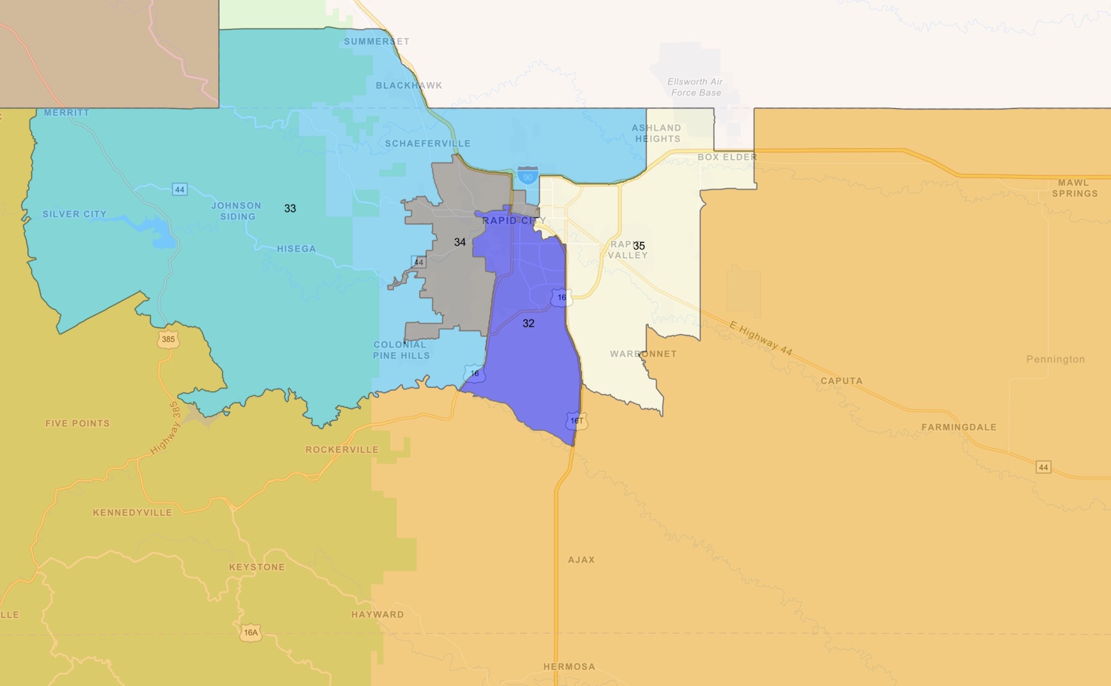
From a purely geometrical perspective, the four incoming Sparrow districts taking up most of Rapid City don’t appear much more compact than the outgoing districts.
- District 35, the I-90 gateway to Rapid City, gets some northern compactness by claiming that one stray square chunk of Box Elder that used to belong to Sturgis/Union Center/Meade boonies District 29 to the north and absorbing that lobe north of I-90 that previously belonged to District 33. But District 35 maintains weirdly bumpy borders west and south.
- District 34, the west Rapid district shown in grey on the old map and darker green on Sparrow (lighter green to the east is District 27) either absorbs or surrenders some of its squigglier boundaries on the old map, but its northward and westward expansions into District 33 still make strange peninsulas.
- District 33, the Hillsiest Rapid district shown in light blue on the old and dark blue on the new, maintains its choosy western boundary (Pactola in, Sheridan out). It loses some of its strange northern lobe over north Rapid, but the northern stretch it maintains becomes stranger, with two small blobs almost broken off by District 34’s northern intrusions. To the south, District 33 reaches east across Mount Rushmore Road to claim a weird chunk of south Rapid. There are thus places where I could launch a drone from District 33, fly straight east, cross into and out of District 34 three times, and still land in District 33. Similarly, I could launch from District 33 in Hisega, fly due east, cross Districts 34 and 32, and end again in 33 at St. Paul’s Lutheran Church, just across the street from Robbinsdale Park.
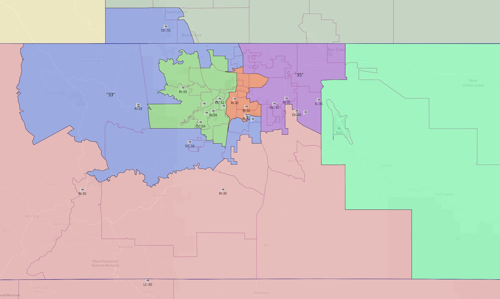
- District 32, the new hopeful base of operations for getting out the Indian vote, is arguably more gerrymandered now than it was before. To the south, where District 32 used to flow sensibly between Mount Rushmore Road and Campbell/16T down to Upper Spring Creek Road, District 32 now goes wounce-a-jounce through Rapid along Fairmont, Maple, Texas, Arizona, Centennial, Maple again, Nebraska, 5th, and Fox Run. District 32 becomes more pinched at its new center downtown as it gives up territory west of West Avenue and Skyline Drive and does not expand much east of East before claiming its new bulge north of North. District 32’s new reach north of I-90 and west of Haines looks like a random drunken walk with District 33.
By pure geometry, the Sparrow map is no neater than the outgoing map; in places, it creates even stranger, more tenuous peninsulas. And some of those peninsulas appear designed to cut past Democratic candidates out of their previous districts while preserving the realms of most Republican incumbents.
Consider District 32: the district may be seen as a hopeful foothold for Democratic organizing, but the Republican Senate made sure the new 32 boundaries still include all three current Republican incumbents while encompassing no 2020 Democratic candidates. Take a closer look at 32’s new, wilder southern boundary:
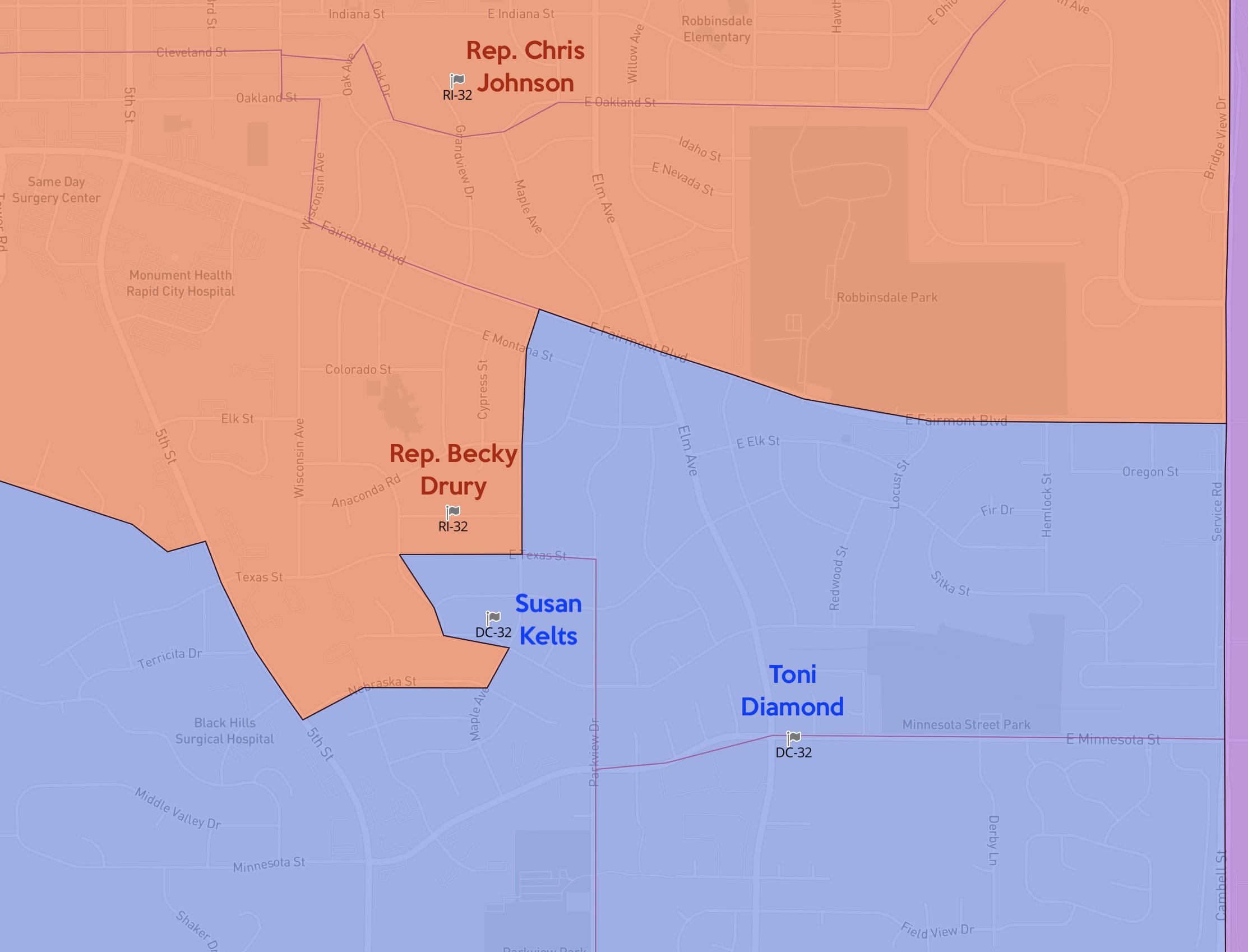
The Sparrow map rolls the southern border of District 32 far north, but it stops one block south of Republican District 32 Representative Becky Drury’s house and cuts east one block before resuming its northward march. Sparrow then ends that march three curvy blocks safely southeast of Republican District 32 Representative Chris Johnson’s house. But in that march, Sparrow rounds a corner at Maple and Centennial to make sure that 2016 and 2018 Democratic House candidate Becky Kelts is carved out of District 32 and drawn into District 33. That new tenuous crook of District 33 also captures 2020 Democratic District 22 House candidate Toni Diamond. If Kelts and Diamond want to run for Legislature again, they can still canvass about 9,200 of their fellow South Rapid residents, but then they’ll have to drive up and out through 32 and 34 to get to the other 15,600 voters spread out across far north North Rapid, Blackhawk, Summerset, Johnson Siding, and Silver City.
Diamond’s other two Democratic ticketmates from 2020, James Preston and Michael Calabrese, are also cut out of District 32. Their 2020 addresses are west of Skyline Drive, so they end up in District 34, which kept all three of its comfortable Republican incumbents—Senator Michael Diedrich, Representative Jess Olson, and Representative Mike Derby—while consigning one of its three 2020 Democratic challengers, George Nelson, to District 33.
District 33 Republican incumbent Representative Taffy Howard got absorbed into District 34’s westward expansion. That might have caused some tension with 34’s Olson, Derby, and Diedrich, but Reps. Olson and Derby didn’t mind: they voted for the Sparrow map. Howard voted against it, but she has chosen to challenge Dusty Johnson for his U.S. House seat rather than seeking her fourth term in the State House, so she won’t be on the ballot against her District 34 colleagues.
But as it did in south Rapid, the Sparrow map halted its expansion just shy of the houses of some favored Republican incumbents. Republican District 33 Representative Phil Jensen and Senator David Johnson both live within shouting distance of each other in the Hills just off Highway 44 and the Hisega Road. The Sparrow map pushed District 34 west on 44 in that big green block that stops less than a mile from Jensen’s and Johnson’s hilly retreats. Whether keeping their district number represents a great favor for Jensen and Johnson is questionable: Sparrow keeps them out of conflict with 34’s incumbents, but they lose a number of their West Rapid constituents and now have to drive through new 34 to get to most of their voters and potential sign-yards in north and south Rapid.
One more clever gerrymander happens at the bottom of District 35, or the new top of District 30. As I noted above, District 35 gained population in the north and thus had to cede population in the south. Meanwhile, District 30 lost eastern Pennington—Wall, Wasta, New Underwood, and Highway 44 from the airport east—to strong Lakota District 27, so it had to creep northward into Rapid compensate. All three Republican incumbents—Senator Jessica Castleberry, Representative Tina Mulally, and Representative Tony Randolph—and all three of their 2020 opponents—independent Brian Gentry and Democrats David Hubbard and Pat Cromwell— live within a two-mile-by-one-mile rectangle in the middle of current 35, right in the balancing zone between Sparrow’s 30 and 35. The Sparrow map keeps the three Republican incumbents together but splits the Democratic challengers:
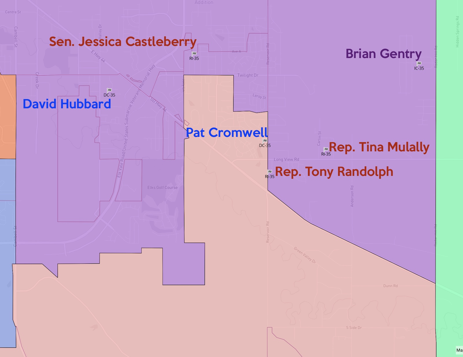
Representatives Randolph and Mulally live south of Cromwell. Randolph lives on the east side of Reservoir Road; Cromwell lives less than a half mile north on the west side of Reservoir Road. Yet Sparrow marches District 30 up the west side of Reservoir Road to grab Cromwell, then stops less than a quarter mile south of Senator Castleberry’s house. Mulally and Randolph can thus continue to drive north on Reservoir on their way to pick up Castleberry to go District 35 events no more than ten miles from their homes, while Cromwell, if she chooses to run again, will get to drive south past Randolph’s house on her way to events an hour-plus away in her new District 30 in Custer, Hot Springs, and Edgemont.
The consolidation of the Native vote in Rapid City is one positive aspect of the new Sparrow redistricting map for the coming decade. But don’t let that one positive development lead you to think the 2021 Legislature did away with gerrymandering.
Outstanding analysis, Cory. Well researched and presented.
OK, I’ll try this again. Say break it down to a vote for class President for second graders. Five rows, the second row has two more people. You are trying to explain the Electoral College to these kids sooo you say the second row has only the same power of voting as the other rows. First I thought that they would only have only three quarters of the vote, but this is the second grade after all and fractions might blow it.
You can say it’s a Republic, and say it like John Wayne to drive it home because it’s still unfair and second graders pick up on that right away. You don’t dare try to explain the Senate but since it’s South Dakota you can simply say the Senate gives the state as much power as California which has 50 times as many people. Their fairness might kick in again. The House you can say South Dakota only has one representative compared to 53 for California so California gets a slight plus there.
You know I’m quiting right here. I gave up religion in high school because I had to teach a second grade Lutheran Sunday School class and it was too hard to snooker them. Sorry.
Maps, like novels and poems, should be read with an assumption of authorial intent in every line.
I enjoy your reviews and perspective. Redistricting is no easy dance. The #1 request at the the public hearings in Rapid was getting North Rapid in one district.
An easy miss in Rapid City is how the precinct lines are driven by geography. Some of the weirdest lines, if you put them on a topo map that also showed roads and homes, would then make sense. Canyons, creeks and mountains don’t lay out as well as our prairies do in eastern South Dakota.
Also, as for people that lost prior races, there’s way too much to juggle to work that into the balance. The map only passed by about one vote in the House. The “beneficiaries” of that supposed aspect, largely voted against it (they are GOP, not Dem). Given all the other personalities and issues that were juggled, I never heard any reference to the folks you referenced who lost – most of them lost by such huge margins that they’d need a special district limited to their homes to be competitive.
Thank you for inspiring public discussion
How are 65 county seats and their bureaucracies either conservative or sustainable? They’re not; but, it is the way Republican cronyism and patronage built barricades to democracy by providing benefits of the public dole to those who say they deplore big gubmint in a state that hates poor people.
New Mexico has a population of over 2 million and is nearly twice as big as South Dakota but only has 33 counties.
https://www.lcsun-news.com/story/news/local/new-mexico/2021/12/17/tribes-prevail-redistricting-plans-advance-new-mexico/8938812002/
Sorry, Cory, I can’t agree that District 32 is anything but gerrymandered. My old neighborhood just south of East/North Avenue should have been attached to District 32, not gerrymandered into District 35. That area has a quite a lot of Native American and lower income residents in smaller homes, rentals apartments, trailer parks, and low income housing, as does North Rapid. That area has much more in common with North Rapid, including being part of Rapid City, than with Rapid Valley and the base area in District 35. Instead District 32 packs some of the wealthier neighborhoods south of Robbinsdale when they should be put into a similar socioeconomic district that spans southeast and southwest Rapid City.
The bottom line is this. Based on 2020 Census numbers, Rapid City should have 3 urban legislative districts, but instead it’s involved in four legislative districts and five if you count the airport.
I drew the Rapid City map while sitting in Heinerts office with a couple Rapid City Republicans there to help guide. Cwach came in and looked it over too. This was before Sparrow was Sparrow and while everyone thought the SCSD was gonna make the maps. We all agreed the Northwest side of 34 was ugly, but the census blocks were absolutely no help and time was ticking; it was the best we could do given the time crunch and geographical constraints imposed by census blocks and super bad Pennington precincts. Re: the southern side of 32, originally that was gonna follow precinct lines, which would have been far more ugly. When I drew the lines, I was the one that proposed cutting some from the south of 32. Original plan was to move in from the west.
Make no mistake, the Republicans we worked with killed a few ideas we had that, in retrospect, were kinda stupid. They worked in good faith and we’re instrumental in getting this done. I find it hard to believe that the D33 GOP in that room willingly would have put Kelts and Diamond in their district while simultaneously making 32 more blue. The fact of the matter, plain and simple, is we never considered where they lived.
I caught my fair share for not making the eastern border of 32 Lacrosse, splitting two precincts. It would have made sense. But again, by the time this compromise map was being drawn, we were expecting everything to already have gone to [ruin].
The person you should be mad at isn’t the legislators, it’s Pennington county commissioners. They have some absolutely trash precinct lines especially looking near the edge of Rapid City. These are boundaries that haven’t changed in any meaningful way since 1980, and I’ve got the 40 years of historical maps to prove it. They sure did carve out America’s Way into her own precinct though, so they do know how to edit precincts.
Since we’re on it, here’s a hint: counties of all shapes and sizes will be redrawing their precincts, as well as county commissioner districts. You wanna see some abhorrent abominations, you start looking there. I know I have been.
This is my neighborhood. I am a couple doors down from Susan and I can tell you these new lines were carefully drawn to keep the Thune Country parts still in 32 while cutting out Susan (and me) and the many apartment dwellers (added since 2010) on the west side of Minnesota. Adding North Rapid also is adding in white flight Republicans north of the mall.
With Cully, I fear what will happen to our school district areas. We never should have abandoned our at-large school board, that decision sealed our current disaster.
Just can’t wait to be represented by the likes of Phil Jensen.