Last updated on 2021-08-30
I’m working on interpreting the data files the United States Census Bureau has made available to legislators and the public for redrawing the maps for Congressional and Legislative districts. I need to get some toys to plug these data into some mapping software and draw some ideal maps for the South Dakota Legislature. But my first glance at the population figures indicate that a majority of our 35 Legislative district must see some significant boundary changes.
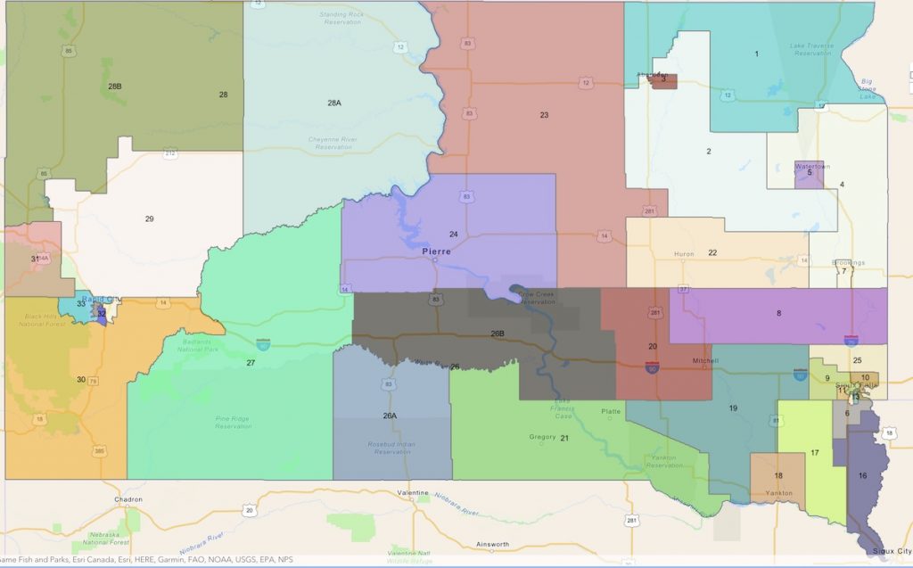
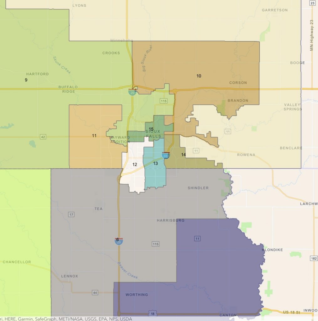
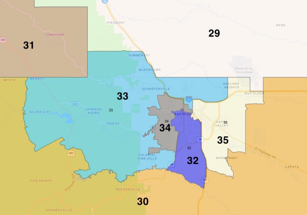
To refresh your memory, here are the Legislative districts the South Dakota Legislature drew in 2011 as the basis for our Legislative elections from 2012 through 2020.


South Dakota’s population has grown from 814,180 in 2010 to 886,667 in 2020. We draw our 35 Legislative districts to have equal population. In 2010, that target was 23,262 people (not just voters, but everybody—kids, felons sitting in prison, immigrants who aren’t citizens, everybody the government must serve). With 72,487 more people in South Dakota, we have to increase our target population for Legislative districts by 2,071, to 25,333 people per Senator.
We could avoid increasing the workload and handshaking that each Senator and Representative must do by adding districts. If we kept our target district population at our 2010 level, the new South Dakotans of the last decade could constitute three whole new Legislative districts of their own. Alas, the state constitution (Article 3 Section 2 and Article 3 Section 5) cap the Legislature at 35 districts, so we’ll have to deal with decreased representation as one of the fruits of increased population.
When we last drew Legislative maps in 2010, federal law allowed for 10% variance—5% above or 5% below the ideal population. So if there’s a geographic community that the Legislature would prefer not to split into separate districts, they can squeeze in to or leave out of a district up to 1,266 people. For example, Lawrence County is currently its own Legislative district (District 31). Lawrence’s population grew to 25,768 in 2020, just 1.72% larger than the ideal 25,333 we’ll aim for in each district. Thus, unless legislators really want to gerrymander 435 Nemo residents out of District 31 and stick them in with Pennington or Meade County voters, they can leave Lawrence County intact as its own complete Legislative District.
By contrast, consider Yankton and Codington counties, the two counties besides Lawrence that are closest to the ideal district population.
Yankton, like Lawrence, is currently its own complete Legislative district (District 18). Those are the only two counties whose populations allowed that convenient mapping in 2010. But while Lawrence County grew over the past decade by 6.9% and stayed ahead of the ideal Legislative district population, Yankton County grew by only 3.9%, to 23,310. That’s 7.99% below the target population, outside the allowable 5% margin either way. Legislators could stretch the range down to allow Yankton to keep its Legislative integrality, but then they’d have only 2% wiggle room above the target for other districts, and that could cause cartographical and mathematical heartburn.
Codington County grew 4.03% to 28,325 residents in 2020. That’s 11.8% above the target, way too big to be its own Legislative district. Thus, as in 2010, legislators will need to carve Watertown, Lee Schoenbeck’s Lake Kampeska shack, and a few other friendly rural conservatives into their own district, then attach the rest of Codington County to some other district sprawling across a couple-three other counties.
According to Census data, as currently drawn, 21 of our 35 districts—that’s three out of five —have 2020 populations that are outside that 5%-above-or-5%-below range around the target district population of 25,333 (red means too small, green means too big):
| District | 2020 population | Difference from ideal (25,333) |
| 1 | 23,193 | -8.45% |
| 2 | 24,405 | -3.66% |
| 3 | 26,506 | 4.63% |
| 4 | 24,391 | -3.72% |
| 5 | 24,953 | -1.50% |
| 6 | 34,840 | 37.53% |
| 7 | 25,207 | -0.50% |
| 8 | 22,023 | -13.07% |
| 9 | 29,462 | 16.30% |
| 10 | 28,364 | 11.96% |
| 11 | 30,219 | 19.29% |
| 12 | 27,580 | 8.87% |
| 13 | 25,212 | -0.48% |
| 14 | 27,628 | 9.06% |
| 15 | 22,868 | -9.73% |
| 16 | 24,967 | -1.45% |
| 17 | 23,640 | -6.68% |
| 18 | 23,310 | -7.99% |
| 19 | 23,084 | -8.88% |
| 20 | 24,366 | -3.82% |
| 21 | 22,315 | -11.91% |
| 22 | 24,336 | -3.94% |
| 23 | 21,425 | -15.43% |
| 24 | 23,453 | -7.42% |
| 25 | 28,046 | 10.71% |
| 26 | 23,067 | -8.95% |
| 27 | 22,297 | -11.99% |
| 28 | 23,891 | -5.69% |
| 29 | 27,790 | 9.70% |
| 30 | 24,497 | -3.30% |
| 31 | 25,768 | 1.72% |
| 32 | 25,661 | 1.29% |
| 33 | 24,761 | -2.26% |
| 34 | 25,197 | -0.54% |
| 35 | 27,945 | 10.31% |
District 8 is Moody, Lake, Miner, and Sanborn counties, all of which saw population declines in the last decade. The Legislature would need to add more than 2,000 people to District 8 just to reach the 5%-under threshold of 24,067. Interestingly, the only adjoining district that has voters to spare is District 25, the Colton-Dell Rapids-Garretson-Valley Springs-Rowena gerrymander of rural Minnehaha County.
The only Legislative district more short of population than District 8 is District 23, the already sparse conglomeration of Campbell, Edmunds, Faulk, Hand, McPherson, Potter, and Walworth counties plus the chunk of Spink County the Republicans gerrymandered in to make sure the Greenfields never had to compete with any tough candidates from Tulare. Potter was the only county in that expanse that added population from 2010 to 2020; the shrinkage everywhere else leaves District 23 15.43% shy of the target. Redistrictors will have to scrape together another 2,642 people to get District 23 up to the 5% below threshold. Neighboring District 3 has over a thousand residents to spare; perhaps Rep. Charlie Hoffman (R-23/Eureka) will be able to convince his colleagues to adjust the gerrymander of Brown County to send some of Aberdeen’s Democrats in the northwest part of town to the oblivion of District 23 again.
The only three districts clinging to Democratic Senators and sanity also have population deficits that will require expanding their borders. District 1 in the far northeast is down 8.45% from the target; District 15 in the heart of Sioux Falls is down 9.73%; and District 27, which includes Pine Ridge and all that empty white space to the north toward the Cheyenne River, is 11.99% below the minimum.
On the growth side, seven Legislative districts in the Sioux Falls metro region—the aforementioned 25, plus 6, 9, 10, 11, 12, and 14—have too many people for one district. The whopper is District 6, the Tea-Harrisburg-Lennox triangle, which has 34,840 people, 37.53% above the ideal and 8,240 more than the 5%-above threshold of 26,600. If we whittle all seven of those districts down to the target population, we’d have 28,806 extra people, too many to pack into a single new district. Shove 2,465 people from Districts 9 and 10 downtown to shore up District 15, and the Sioux Falls overage is still 26,219, requiring a new district somewhere in the greater Sioux Falls metro area.
Rapid City doesn’t quite need a whole new district. Districts 29 and 35 each have more than the 5%-above threshold, but their surpluses are only a fraction of a district’s worth. Surrender more of eastern Pennington to District 27, and the Rapid City map can be rebalanced without adding a district.
But where then do we eliminate one district to make up for the one we must add in the Sioux Falls metro? Just looking at district-level population data, I don’t see an obvious and easy split. No one district is so short of population that it could simply be chopped in half and handed to two adjoining districts. Making room for a new Sioux Falls district will require some more creative remapping, like dividing the eastern chunk of District 19 among adjoining short districts 18, 17, 8, and 20, dispersing the western area of District 21 into District 26 (with room made there by ceding some of 26 to 27 and 24), and merging the remainders of 19 and 21 into a single new district centered on Wagner, Parkston, and Tyndall.
If any of you find a cheap and easy tool for translating the local Census data into a map tool, let me know, and maybe we can start drafting some fair Legislative district maps to share with our legislators, who I’m sure will be glad to have our input in crafting colorblind, non-partisan maps for the 2022 Legislative elections.
Related Reading: Senate President Pro-Tem Lee Schoenbeck hints at giving District 23 an Aberdeen-ward gerrymander. But interestingly, he proposes going to war personally against the Greenfields by making District 2 disappear, sending Rep. Lana Greenfield (R-2/Doland) to primary it out against the Republican powers in Beadle County while dragging Senator Brock Greenfield (R-2/Clark) into a new District 5 where he would have to face Schoenbeck in a primary… which could be decided in a good drinking contest.
They get much finer detailed information than what you are using. They can just adjust boundaries as needed.
Donald, I think I have the detailed Census block data; I just need to get a tool that will let me plot those blocks on a map to make contiguous zones.
Instead of moving boundaries around, why can’t the legislatures make people move into the places they want them to live? Oh wait, that seems silly.
What they will do is draw lines around and down the streets in front of certain houses belonging to some in the legislatures. Instead of more districts, we should have far less. This makes individuals in the legislatures more powerful, and easier to get connected to the people they need to so the votes go right.
Colorado now has an independent redistricting commission, showing what Democrats do when they’re fully in charge of the state government.
We share.
The commission has four from each of the three political parties, which are of equal membership.
Republican, Democrat, and Unaffiliated.
t’s been a while since I studied the Sioux Falls electorate, but let me suggest they should go horizontal across Sioux Falls, rather than vertical. That might better reflect the socioeconomic structure of the city.
Porter, I really like your post’s point. Our problem tho, is people who have drunk so much Republican Koo-Aid they are so like the wino or alcoholic that keeps on intaking alcohol even tho he/she’s aware of the results. Until we in SD vote “D” enough we will remain in the political darkness created by the GOP.
I agree, Jake.
SD has as much chance of not gerrymandering as Colorado has in banning CRT.
Visit Colorado … you know, for the scenery. #grins
A couple of Republican readers were quick to point out that the Greenfields are both term-limited. Senator Schoenbeck’s dissolution of District 2, which is in itself a good idea, ensures that the Greenfields will not return to the Legislature, which is also a good idea.
Well…Donald’s suggestion about a vertical division of the Sioux Falls metro into districts appears to produce another district that might go democratic in the future. The Republicans will bend over backwards to prevent that from happening.
Arlo, I’m not concerned about what party people identify with. If I had my way, a candidate would not run on a party ticket. He or she would have to earn people’s votes on issues, biography and character. I’m interested in how people are represented, not on how politicians are represented. I realize that politicians like to choose their own voters, and voters have allowed them to do that. That has to change.
My idea may not be the best one or up to date. I’m going on past understanding of Sioux Falls socioeconomic conditions, which is one way of looking at how to draw such maps to assure fair representation. There are other ways, of course.
Oh grudz, its so easy to gerrymander right now. Even I know who’s Republican or Democrat on my street. America is always going to be ruled by a wealthy minority. The tax break that Trump gave affected 82 family’s above all. Hail the aristocracy.
Well, Dona;d, ..your position on redistricting is quite high minded…I doubt that your philosophy will prevail as redistricting is most often performed by the Republicans with the same ethics and gusto as a midnite knife fight in a dark alley.
Donald, I support your premise that state and county elected officials should be non-partisan.
Nebraska has a unicameral legislature with 49 senators with no party affiliation. It. Works.
John, however, if you listen to Nebraska Public radio’s reporting on the Unicameral legislature – they ALWAYS identify the party of the various legislators. They also point out how voting on various bills and measures goes along party lines.
https://www.districtbuilder.org/
http://autoredistrict.org/
The above are two free districting software packages. Haven’t tried them myself, but…… give ’em a try Cory – see what you think.
This article has several gerrymandering ideas, including reference Project Redmap – the recent GQPs effort after the previous census to paint legislatures red.
I maintain that school district boundaries should be the foundation for voting districts. School district boundaries exist for compactness, shortest transportation need for the kids (and parents). If a voter population necessitates going outside a school district, then grabbing a “sub” district i.e., an adjacent grade or middle school boundary to complete a voting district’s balancing need. Using school districts as the foundation for voting districts, precincts, wards, etc.
https://www.theguardian.com/us-news/2021/aug/22/gerrymandering-us-electoral-districts-congress
John, it would be interesting to see if tying Legislative districts to school districts would have a positive effect on Legislative representation, getting lawmakers to focus more on the needs of the districts they represent, and maybe focus more civic attention on school boards as well, or if there’d be some negative feedback that would make school board elections more partisan.
Richard! Holy cow! DistrictBuilder looks like exactly the tool I need! Thanks!
You are most welcome.