Those of you who’d like to compare the House Grouse and Senate Blackbird redistricting maps can try reading the text of the two bills proposed to codify the maps… but I don’t recommend it. Here are the texts of the descriptions of just the first three districts in House Bill 1001 and Senate Bill 1:
HB1001:
(1) District No. 1:
(a) Day, Marshall, and Roberts counties; and
(b) The portion of Grant County consisting of precincts Dummann Tucholke, Paul Dummann, Dave Forrette, and Gene Mann.
(2) District No. 2:
(a) Clark and Spink counties;
(b) The portion of Brown County consisting of precincts VTD-precinct 3 Aberdeen, VTD-precinct 8 Aberdeen, VTD-precinct 9 Aberdeen, VTD-precinct 10 Aberdeen, VTD-precinct 15 Franklin-Carlisle-Ravinia-Mercier-LincolnTwp, VTD-precinct 16 WAberdeenTwp, VTD-precinct 17 Highland-NewHope-WarnerTwp-Warner, and VTD-precinct 18 Gem-WRondell-ERondellTwp-Stratford; and
(c) The portion of Brown County in VTD-precinct 12 EAberdeen, the blocks of: 460139514004013, 460139514004014, 460139517002022, 460139517002066, 460139517002067, 460139517002070, 460139517002079, and 460139517002086.
(3) District No. 3:
(a) The portion of Brown County consisting of precincts VTD-precinct 1 Aberdeen, VTD-precinct 2 Aberdeen, VTD-precinct 4 Aberdeen, VTD-precinct 5 Aberdeen, VTD-precinct 6 Aberdeen, VTD-precinct 7 Aberdeen, VTD-precinct 11 Aberdeen, VTD-precinct 13 Shlby–Clmbia-Cmbria-OrdwyTwp-ClmbiaCity, VTD-precinct 14 Oneota-Brnrd-Wstprt-GrlndTwp-WestprtCty, VTD-precinct 19, VTD-precinct 20 SDetroit-ClaremontTwp-ClaremontCity, VTD-precinct 21 Lbrt-Hcla-Prt-Grnld-Lnsg-Nth-DtrtTwp-HclCy, and VTD-precinct 22 Plmr-Ocla-Savo-Alsn-Frdrck-RchdTwp-FrdrCy; and
(b) The portion of Brown County in VTD-precinct 12 EAberdeen, the blocks of: 460139514004001, 460139514004002, 460139514004003, 460139514004004, 460139514004005, 460139514004006, 460139514004007, 460139514004008, 460139514004015, 460139514004016, 460139514004017, 460139514004018, 460139514004019, 460139514004020, 460139514004021, 460139514004023, 460139514004032, 460139514004034, 460139514004039, 460139514004040, 460139514004041, 460139514004043, 460139514004044, 460139514004046, 460139514004056, 460139514004057, 460139514004059, 460139514004060, 460139514005000, 460139514005001, 460139514005010, 460139514005012, 460139518001000, 460139518001002, 460139518001003, 460139518001008, 460139518001014, 460139518001017, 460139518001028, 460139518001029, 460139518001030, 460139518001055, 460139518001056, 460139518001057, 460139518001058, 460139518001059, 460139518001060, 460139518001061, 460139518001062, 460139518001066, 460139518001067, 460139518001068, 460139518001070, 460139518001071, 460139518001072, 460139519003004, 460139519003005, 460139519003006, 460139519003007, 460139519003008, 460139519003009, 460139519003010, 460139519003011, 460139519003012, 460139519003013, 460139519003014, 460139519003015, 460139519003016, 460139519003017, 460139519003018, 460139519003019, 460139519003020, 460139519003021, 460139519003026, 460139519003298, 460139520004240, 460139520004241, 460139520004255, 460139520005268, 460139520005269, 460139520005270, 460139520005271, 460139520005272, 460139520005273, 460139520005274, 460139520005275, 460139520005276, 460139520005277, 460139520005278, 460139520005281, 460139520005282, 460139520005284, 460139520005285, 460139520005286, 460139520005287, 460139520005288, 460139520005289, 460139520005290, 460139520005291, 460139520005292, 460139520005293, 460139520005294, 460139520005295, 460139520005296, 460139520005297, 460139520005298, 460139520005299, 460139520005300, 460139520005301, 460139520005302, 460139520005303, 460139520005304, 460139520005305, 460139520005306, 460139520005307, 460139520005308, 460139520005309, 460139520005310, 460139520005311, 460139520005312, 460139520005313, 460139520005314, 460139520005315, 460139520005316, 460139520005317, 460139520005318, 460139520005319, 460139520005320, 460139520005321, 460139520005322, 460139520005325, 460139520005326, 460139520005327, 460139520005328, 460139520005339, 460139520005340, 460139520005341.…
SB1:
(1) District No. 1:
(a) Day, Marshall, and Roberts counties;
(b) VTD-precinct 14 Oneota-Brnrd-Wstprt-GrlndTwp-WestprtCty, VTD-precinct 15 Franklin-Carlisle-Ravinia-Mercier-LincolnTwp, VTD-precinct 21 Lbrt-Hcla-Prt-Grnld-Lnsg-Nth-DtrtTwp-HclCy, and VTD-precinct 22 Plmr-Ocla-Savo-Alsn-Frdrck-RchdTwp-FrdrCy;
(c) The portion of Brown County in VTD-precinct 16 WAberdeenTwp, the blocks of: 460139513002010, 460139513002011, 460139513002021, 460139513002026, 460139513002027, 460139513002028, 460139513002029, 460139513002030, 460139513002031, 460139513002032, 460139513002033, 460139513002034, 460139513002035, 460139513002036, 460139513002037, 460139513002038, 460139513002039, 460139513002040, 460139513002078, 460139513002079, 460139513002080, 460139513002081, 460139513002082, 460139513002083, 460139513002084, 460139513002098, 460139517002006, 460139517002007, 460139517002008, 460139517002010, 460139517002011, 460139517002013, 460139517002015, 460139517002016, 460139517002017, 460139517002019, 460139517002020, 460139517002021, 460139517002023, 460139517002040, 460139517002041, 460139517002042, 460139517002043, 460139517002044, 460139517002045, 460139517002046, 460139517002047, 460139517002048, 460139517002049, 460139517002050, 460139517002051, 460139517002052, 460139517002053, 460139517002056, 460139517002057, 460139517002063, 460139517002064, 460139517002065, 460139517002081, 460139517002094, 460139517003007, 460139517003016, 460139517003034, 460139517003035; and
(d) The portion of Brown County in VTD-precinct 8 Aberdeen, the blocks of:460139515002014, 460139515002015, 460139515002016, 460139515002017, 460139515002018, 460139515002019, 460139516002006, 460139516002007, 460139516002008, 460139516002009, 460139516002010, 460139516002011, 460139516002024, 460139516002025, 460139516002026, 460139516002027, 460139516002028, 460139517001027, 460139517001028, 460139517001029, 460139517001030, 460139517001031, 460139517001032, 460139517001033, 460139517001034, 460139517001035, 460139517001036, 460139517001037, 460139517001038, 460139517001039, 460139517001040, 460139517001041, 460139517001042, 460139517001043, 460139517001044, 460139517001045, 460139517002009, 460139517002012, 460139517002014, 460139517002018, 460139517002024, 460139517002025, 460139517002026, 460139517002027, 460139517002028, 460139517002029, 460139517002030, 460139517002031, 460139517002032, 460139517002033, 460139517002034, 460139517002035, 460139517002036, 460139517002037, 460139517002038, 460139517002039, 460139517003000, 460139517003001, 460139517003002, 460139517003003, 460139517003004, 460139517003005, 460139517003006, 460139517003008, 460139517003009, 460139517003010, 460139517003011, 460139517003012, 460139517003013, 460139517003014, 460139517003015, 460139517003017, 460139517003020, 460139517003032, 460139517003033, 460139517003036, 460139517003037, 460139517003038, 460139517003040.
(2) District No. 2:
(a) The portion of Minnehaha County consisting of precincts VTD VP 03, VTD VP 05, VTD VP 15, VTD 4-11, VTD VP 01, and VTD VP 02;
(b) The portion of Minnehaha County in VTD 2-14, the blocks of: 460990104012001, 460990104012002, 460990104012003, 460990104012004, 460990104012005, 460990104012006, 460990104012007, 460990104012008, 460990104012009, 460990104012010, 460990104012011, 460990104012012, 460990104012013, 460990104012014, 460990104012015, 460990104012016, 460990104012017, 460990104012018, 460990104012019, 460990104012020, 460990104012021, 460990104012022, 460990104012023, 460990104012024, 460990104012025, 460990104012026, 460990104012027, 460990104012028, 460990104012029, 460990104013064, 460990104013065, 460990104013081, 460990104013085, 460990104013086, 460990104013087, 460990104013088, 460990104022035, 460990104022036; and
(c) The portion of Minnehaha County in VTD 2-7, the blocks of: 460990104011000, 460990104011001, 460990104011002, 460990104011004, 460990104011006, 460990104011008, 460990104011010, 460990104011011, 460990104011012, 460990104011013, 460990104011014, 460990104011015, 460990104011016, 460990104011017, 460990104011018, 460990104011019, 460990104011020, 460990104011021, 460990104011024, 460990104011025.
(3) District No. 3:
(a) The portion of Brown County consisting of precincts VTD-precinct 1 Aberdeen, VTD-precinct 2 Aberdeen, VTD-precinct 3 Aberdeen, VTD-precinct 4 Aberdeen, VTD-precinct 5 Aberdeen, VTD-precinct 6 Aberdeen, VTD-precinct 7 Aberdeen, VTD-precinct 9 Aberdeen, VTD-precinct 10 Aberdeen, and VTD-precinct 11 Aberdeen;
(b) The portion of Brown County in VTD-precinct 12 EAberdeen, the blocks of:460139514004001, 460139514004002, 460139514004003, 460139514004004, 460139514004005, 460139514004006, 460139514004007, 460139514004008, 460139514004013, 460139514004014, 460139514004015, 460139514004016, 460139514004017, 460139514004018, 460139514004019, 460139514004020, 460139514004021, 460139514004023, 460139514004032, 460139514004034, 460139514004039, 460139514004040, 460139514004041, 460139514004043, 460139514004044, 460139514004046, 460139514004056, 460139514004057, 460139514004059, 460139514004060, 460139514005000, 460139514005001, 460139514005010, 460139514005012, 460139517002022, 460139517002066, 460139517002067, 460139517002070, 460139517002079, 460139517002086, 460139518001000, 460139518001002, 460139518001003, 460139518001008, 460139518001014, 460139518001017, 460139518001028, 460139518001029, 460139518001030, 460139518001055, 460139518001056, 460139518001057, 460139518001058, 460139518001059, 460139518001060, 460139518001061, 460139518001062, 460139518001066, 460139518001067, 460139518001068, 460139518001070, 460139518001071, 460139518001072;
(c) The portion of Brown County in VTD-precinct 13 Shlby–Clmbia-Cmbria-OrdwyTwp-ClmbiaCity, the blocks of: 460139514004009, 460139514004010, 460139514004011;
(d) The portion of Brown County in VTD-precinct 16 WAberdeenTwp, the blocks of: 460139513002020, 460139513002024, 460139513002046, 460139513002047, 460139513002049, 460139513002054, 460139513002066, 460139513002070, 460139513002072, 460139513002073, 460139513002074, 460139513002077, 460139513002085, 460139513002086, 460139517001008, 460139517002000, 460139517002001; and
(e) The portion of Brown County in VTD-precinct 8 Aberdeen, the blocks of: 460139515002020, 460139515002021, 460139515002022, 460139515002027, 460139516002004, 460139516002005, 460139516002012, 460139516002013, 460139516002022, 460139516002023, 460139516002029.…
Uff da. Legislators debating these bills have to have a lot of faith in the Legislative Research Council to have written down all the right numbers.
Numerically, the House Grouse map does a better job of staying close to the target population of 25,333 for each district. The House’s population variations do not exceed 5% above or below the target. The Senate Blackbird map (at least in the last form scored and posted by the LRC) allows two districts to vary by more than 5% from the target: District 26, including the Rosebud reservation, would be 7.80% below the target, while District 27, including Pine Ridge, would be 5.60% below the target. Those exceptions appear to maintain American Indian majorities in those two districts and may be interpreted as a response to the suspected Census undercount of the American Indian population in South Dakota. Article 3 Section 5 of the South Dakota Constitution says legislative districts “shall have population as nearly equal as practicable, based on the last preceding federal census.” Whether we can base our population apportionment on evidence of errors in the Census would be an interesting question to litigate.
Geographically, we can look at contiguity and compactness for signs of gerrymandering. Here are the most recent maps posted by the LRC (maps have been amended since, but these maps show each chamber’s original intent):
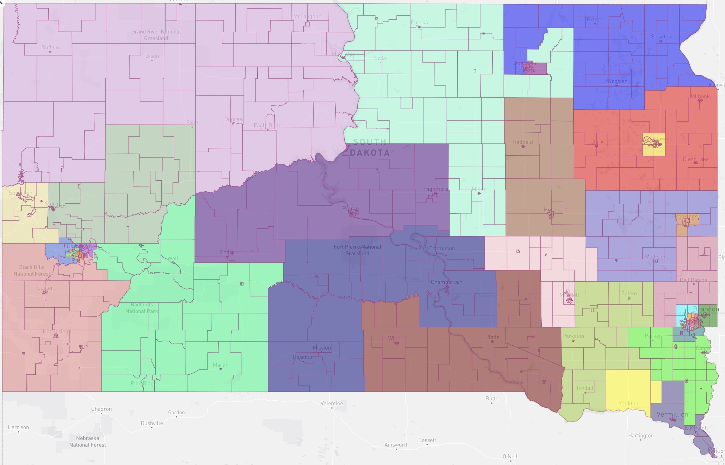
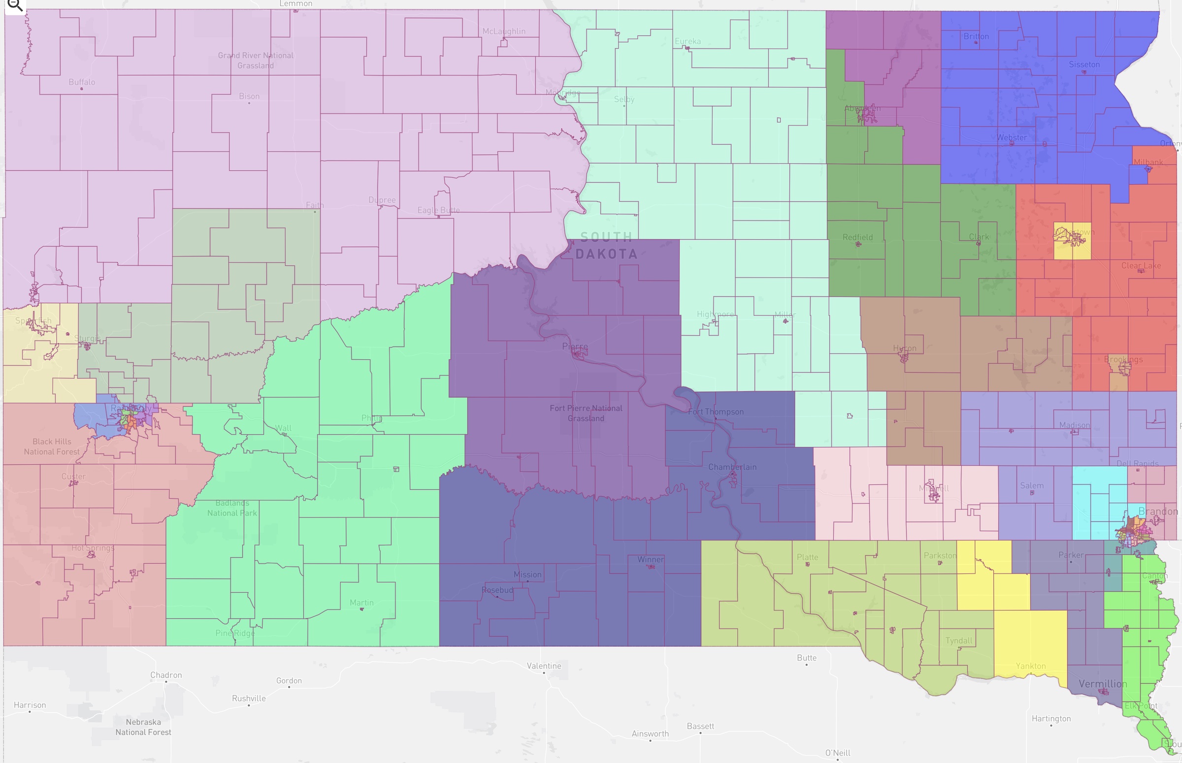
Each map includes instances of cartographic quirkery. The Senate maintains the weird gerrymandering of Brown County into three districts; the House splits Brown in two along a slightly more sensible, less twisty zigzag that makes sense alongside adjoining district. However, the House map radically changes the division of Aberdeen proper, taking Northern State University and everything west of Main Street out of incumbent Novstrup, Perry, and Dennert’s District 3 and throws them into the even more conservative and far-flung District 2 to the south, currently represented by Weis and the Greenfields.
The Senate makes more contortions in south-central South Dakota than does the House. In the southeast, the Senate chooses to split the tricky Lincoln-Turner-Clay-Union region into rough north and south chunks. The House prefers to split that region into west and east chunks that more closely maintain current district boundaries for its conservative incumbents. Both chambers make some squiggly splits in Rapid City, but in Sioux Falls, the Senate’s districts make fewer jigsaw incursions into each other than the House’s.
House State Affairs is formally reviewing the Senate map right now. Whether the Legislature will agree on either map or some compromise map by the end of the day is unknown.
Well both maps have a light purple northwest winter wind face blowing in. The blackbird has a number one around Aberdeen, did you put that in Cory? The blackbird has a bit more integration of east and west. The colors on the eastern border are much more pleasing. Who put those in? This is way to complicated for any reasonable debate. Its my wine time after all. By the time I got to 460139517002022 my old Aberdeen block, I was done.
House version
The Grouse version is more friendly to those who are insaner than most, I suspect.
Well…pick your poison…can’t say I can find a district on either map composed of a certain majority of reasonable people.
You might be righter than right, Mr. Blundt. It must be very stressful to try and crack and pack these districts the right way, for it weighs heavy on some of the fellows tasked with it to the point of collapse and PTSD.
Well at least they had to good sense not to have selected Owl as a name for one of their maps.
grudz – In saying “the right way”, you obviously (though subconsciously) do not favor the “correct way” – as well as would the “left” way not be your preference. Correct?