In random Google paths, my blog brain went from looking up areas of of South Dakota towns for comparison to our average farm sizes to mapping South Dakota’s center of population.
Census data show that South Dakota’s center of population has followed a clockwise arc around Wessington Springs. In 1880, the center of our someday state’s population was about a mile south and a half mile west of Gann Valley:
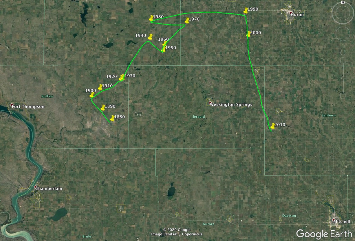
For the next five Censi, the state’s center of population remained in Buffalo County, heading northwest through our first decade of statehood in the general direction of Nick Nemec’s house, then turning northeast toward Huron. That northeast trend continued, with significant zigs, through Hand and Beadle County into 1990, at which point the state’s center of population was a mile south of HIghway 14 and ten miles west of Huron.
Then the population took a dramatic southerly turn toward Mitchell, popping down to a mile east of Virgil in 2000 and then down to the west edge of Sanborn County about five miles south-southwest of Woonsocket.
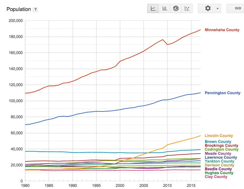
That recent shift toward the southeast is explained pretty easily by the population surges in the Sioux Falls and Rapid City metros:
The 2000-to-2010 hop was over 20 miles, the largest in our history and just a touch larger than the 1980-to-1990 shift toward Huron. Given the steady population trends since 2010 in the above chart, might we see the next hop all the way down to I-90 in Davison County?
Where are all those 13000 jobs trump created, how much are they paying low wages probably.South Dakota does a great job of sending their youth out of SOUTH DAKOTA.We do not grow much as a state while the east and west coast get our best.A state that does not want equal rights for the females of our state, embarrassed enough.
So when I was a kid I lived in SD’s population center. I saw the population leave too, my family of 8 beings were part of the trend.
That map is very interesting to me. From territorial days until the 1900 census, the state’s growth was trending westward. That probably reflects white colonialist settlement on Treaty lands in the west as Indians were settled on reservations.
Indians living on reservations were not included in the US census until 1890, and even then it may have been spotty for that census and several following. Indians living off-reservation were counted in the US census from early on, apparently. There was a yearly census taken on most reservations for quite a while. Liz’s great-grandfather was white, but he is listed as an Indian on some of those those censi. I like to think that he identified as Indian because his wife was Indian and his children were Indian, and he wanted to maintain solidarity with his family. But, there could have been nefarious reasons for identifying as Indian, too.
At any rate, Indians weren’t allowed to vote until 1924, and states set their own election laws, and county officials didn’t always follow the law, even when Indians were give state rights to vote. Liz’s father wasn’t allowed to register to vote, when he tried. He was so humiliated by that that he never registered, so he never voted once in his life. He worked, paid taxes for years, but never voted. So, the censi that counted Indians did so only to provide more power to the local white population. And some people don’t think there is “white privilege.”
I’m fascinated by the general northern trajectory of the population center from territorial days to 1980 with the short dip in the 1940s. What was happening? It seems the southern towns didn’t grow as fast northern towns during that time, but the war years and bases in Sioux Falls and Rapid City added population to the cities. Thus, the dip south during that time.
I was a child in the 1950s and 1960s. That seems to be a time of relative stability with little change in the state population then. The baby boom seems to have been more significant in the east. I wonder if those boomers moved west during the 70s. I know there was an expansion at Ellsworth AFB during the 70s.