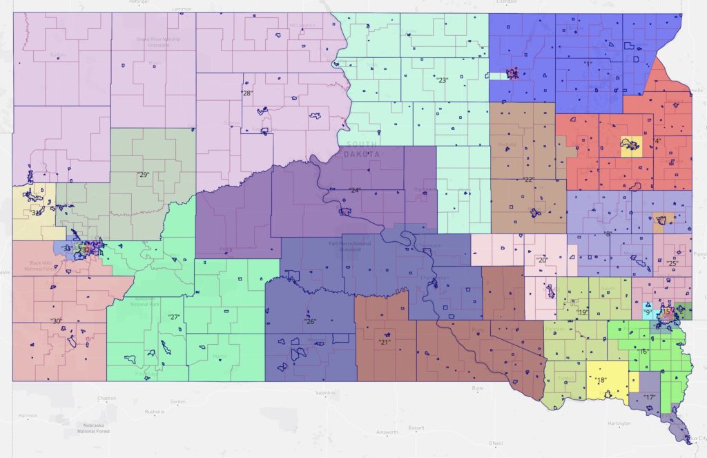
Launching a once-in-history impeachment proved easier than completing the once-a-decade drawing of Legislative districts. Negotiations and cartographic scribblings dragged on at the Capitol through a second day of Special Session, only to be brought to a sudden halt by Representative Kent Peterson’s (R-19/Salem) passing out in caucus and getting hauled to the hospital.
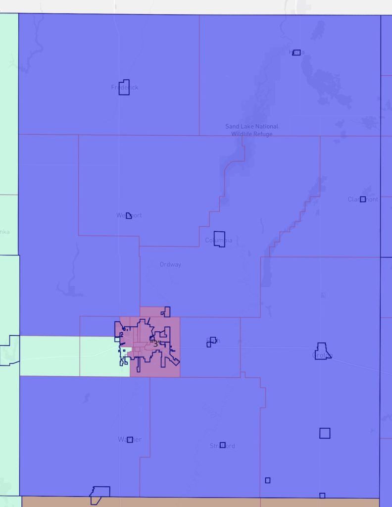
Maybe what floored Majority Leader Peterson was the new Sparrow map, which reconfigures the gerrymandering of Brown County:


The Sparrow map reduces sparsely populated north-central District 23’s unavoidable sprawl by injecting itself into Brown County to claim the Highway 12 corridor and a southwestern chunk of Aberdeen. In exchange, Aberdeen’s “urban” District 3 becomes more compact, surrendering its eastern rural Bath half. District 1, one of the last bastions of Democratic competitiveness, slides westward, taking Bath from District 3 and the south and east portions of Brown County that currently fall into sprawling District 2 to the south but giving up the southeastern corner of Roberts County, the chunk outside the diagonal eastern boundary of the Sisseton-Wahpeton reservation, to District 4 to the south.
Geometrically, Districts 1 and 3 come out looking better. So does the carve-up of old District 2, which now, instead of running from the middle of Brown County all the way down to south of Kristi and Bryon’s house on Highway 81 toward Hayti, breaks into a more compact District 22 for Spink and Beadle counties with a bit of Clark, the western half of the newly horned District 4 donut (whose hole is Schoenbeck Island around Watertown-Kampeska), and the northwestern lobe of a new District 8 that reaches north from Madison and up into rural Brookings County instead of east and west along Highway 34.
But note that in the southeast, Moody and Lake counties, centers of some Democratic hope, have been split apart, with Madison now joined with conservative Volga in District 8 and Flandreau and the rest of Moody County joined to District 25, where radical wingers Jon Hansen and Tom Pischke reign.
Back to Brown County: that odd little incursion of District 23 still doesn’t fully resolve the population imbalance. District 23 remains 1,160 people short of the target population of 25,333, a 4.5% deficit. Districts 1 and 3 both have more than 1,260 people too many (1,262 in 3, 1,267 in 1, both at 5.0% surplus). We could strike a little better balance and better geometry by giving 23 a broader slice of western Brown (why not Richmond Lake to go with Mina?).
We’ll find out this morning whether further optimization of the Legislative maps is possible. The House is scheduled to reconvene at 10 this morning.
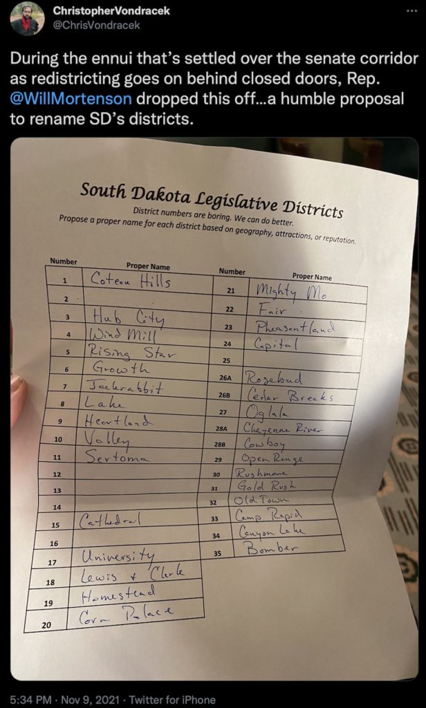
Related Reading: Christopher Vondracek gets this amusing proposal from Rep. Will Mortenson (R-24/Pierre) to give our numbered districts names:

District 23 just wanted the goodwill.
Update: Sparrow passes, with District 23’s finger into Brown County intact! Rep Taffy Howard complained about being “bullied” by the Senate (the hardest-right wingers are the most sensitive snowflakes), but the conservatives couldn’t kill the Senate compromise. The House passed the Sparrow map 37–31. Senate passed Sparrow 30–2. I’m waiting for LRC to post the roll call votes.
Can Governor Noem veto this action or is this issue resolved for the next ren years???
ten years?
Can we see the details of the Rapid City and Sioux Falls Districts in map form anywhere?
I second Kyle’s question above. I have searched for detail maps of the metro boundaries but have come up empty.
Mr. Blundt, the reports in the media, which is very unreliable, say that Governor Noem signed her name in big bold letters to this Sparrow.
Through use of “Dave’s Redistricting Map, LLC” (linked elsewhere on this blog) I was able to enlarge the map to see block-by-block details. Thanks, Dave!
What does the darkening of this District numbered 1 mean for Ms. Wismer in her come-back attempts to retake a seat in the legislatures? She is not in Mr. H’s old district where he ran, is she, but in the corner district they carved some notches out of.