Black Elk Peak Resurveyed: 11 Feet Shorter Than Labeled!
By Cory Allen Heidelberger on 2016-12-26
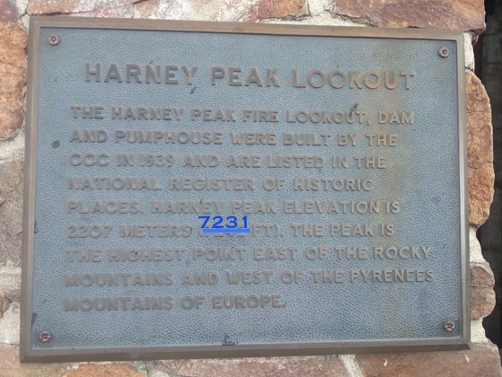
Black Elk Peak isn’t as tall as we thought it was. Black Hills photographer Paul Horsted enlisted Nebraska surveyor Jerry Penry to remeasure the mountain and discovered that the bronze plaque at the top pegging the altitude at 7,242 feet is generous by eleven feet:
Minor revision…
In September, Penry and six team members spent two days of their own time and resources producing what might be the best-ever measurement of the elevation of Black Elk Peak.
The team determined that the highest natural point on the peak — excluding the stone-built fire lookout tower that sits atop it — is 7,231 feet above sea level. That is lower than the 7,242 feet listed on the bronze plaque at the summit, but still high enough to be the tallest mountain in the state. The team also determined that the highest man-made point on the peak — the tip of the lookout tower’s lightning rod — is 7,262 feet [Seth Tupper, “How South Dakota’s High Point Ended up Shorter Than Thought,” Rapid City Journal, 2016.12.26].
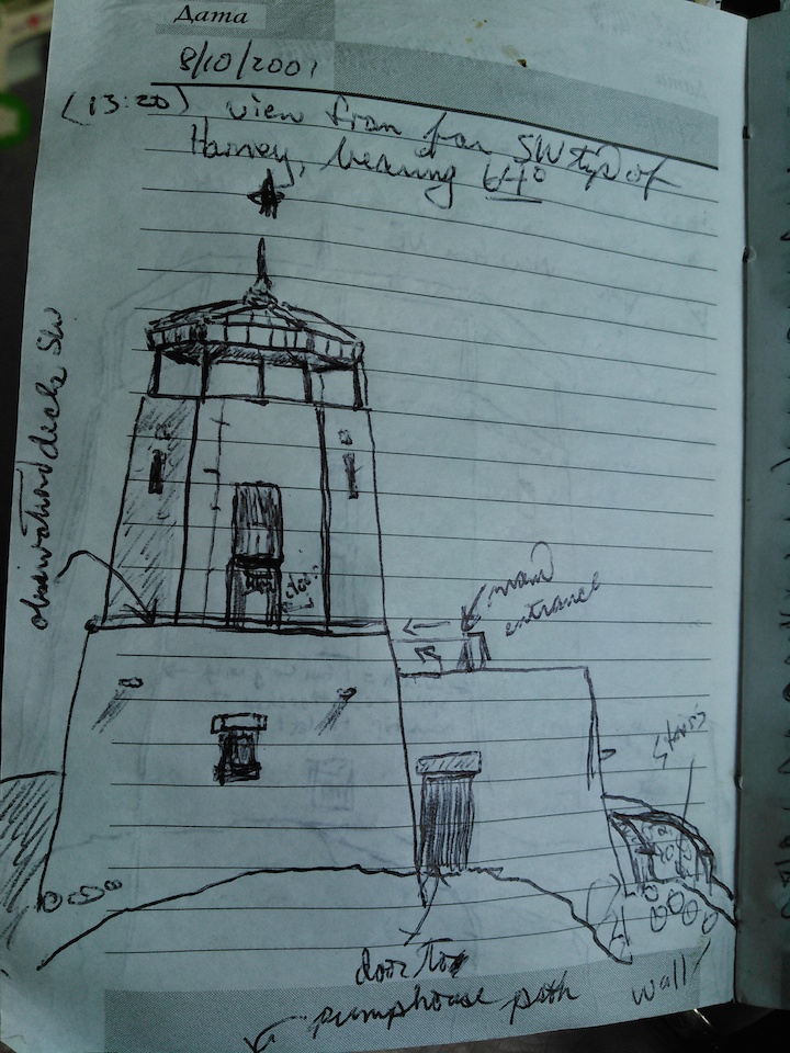
CAH, sketch of Black Elk (then Harney) Peak fire tower, made on site, 2001.08.10.
Penry provides a detailed explanation of his team’s survey, conducted September 15 and 16, 2016, complete with field notes and photos of the mountain, the team, and a mountain goat who supervised. Penry found that the 7,242-foot mark goes back to surveys from the late 1800s that were never rigorously updated, plus some variation introduced by the couple feet of rock blasted off the mountain in 1911 to provide a level surface for the first fire tower. That blasting removed the 1893 triangulation point that was the basis for pre-Jenry elevations.
Penry also resolved dispute over whether “McGillycuddy Peak”, the unofficially named spire 300 feet south of Black Elk Peak, might actually be taller. Penry notes that Valentine Trant McGillycuddy, who was the first white man to document his ascent of Black Elk Peak, got the impression on his first 1875 ascent that that southern spire was taller than the spot the lookout tower and his ashes(!) now occupy. Penry says that McGillycuddy may have been right in 1875 and that erosion and climbers may have knocked some rock off that spire. But today, by Penry’s survey, McGillycuddy Peak is 1.91 feet lower than the highest natural rock on Black Elk Peak.
Elevated Trivia:
Penry’s downward revision does not change South Dakota’s rank among state’s for highest elevation. We’re still #15, behind Texas, whose Guadalupe Peak is 8,751 feet above the Gulf of Mexico, and ahead of North Carolina, whose Mount Mitchell is 6,684 feet above the Atlantic.
We also remain 13th among states for average elevation, at 2,200 feet. Aside from high points in Hyde, Potter, and Walworth counties, everything 2,200 feet and up in South Dakota is in West River. But don’t back out of your East River land deal: if global warming melts all of the ice caps, the seas will only rise 216 feet.
At the end of the Cretaceous Period 65 million years ago, Black Elk, McGillycuddy, and neighboring peaks may have been over 15,000 feet high. Assuming a steady rate of erosion, Mother Nature would have taken 89,000 years to knock eleven feet off Black Elk Peak.
Regardless of elevation, and in consideration of McGillycuddy Peak, Black Elk/Harney Peak shall be known as Blarney Peak – on St. Patrick’s Day only.
leslie
2016-12-26 17:41
(CNN)Mount Everest, the world’s highest peak, was moved 3 centimeters (about 1.2 inches) southwest by the magnitude-7.8 earthquake that devastated Nepal in April, Chinese authorities say.
But the April 25 quake, which left more than 8,000 people dead, did not affect the height of the 8,848-meter (29,029-foot) mountain, according to the report by China’s National Administration of Surveying, Mapping and Geoinformation.
Chinese state media reported the administration had set a satellite monitoring system on the peak in 2005 to observe the movement of the mountain.
In the decade since, Everest had been moving northeast at a speed of 4 centimeters a year, and had grown by 0.3 centimeters annually, state media reported.
grudznick
2016-12-26 17:55
Interestingly enough, Mt. Everest, another mountain named after a white guy which has other names by the various indigenous peoples who claim it as sacred to them, was listed at 29,028 when first climbed by Norgay and Hillary, and is now listed at 29,035 by various authorities outside of the internet. Also interesting is that Mt. Everest, named after Mr. Everest I presume, was also listed at 29,028 when possibly climbed up but not climbed down by George Mallory. I guess the point is that mountains names and heights both change according to people but the mountains themselves really don’t much care.
John Kennedy Claussen, Sr.
2016-12-26 17:58
Well, hopefully we will not have to resort to this:
John W., I suppose it has as much meaning and purpose as all the other surveying that we do. We measure it for the same reason we climb it, because it is there.
But I can also come up with scientific reasons to gather this data. Accurate data helps us understand erosion and perhaps shifts in the earth’s crust. Altitude factors in weather and plant growth. Sure, it’s only a few feet difference, but having the numbers right makes the data better.
John W.
2016-12-28 10:56
Corey: Remember our discussion on monitoring, measurement and statistical reliability??? In order to have any meaning at all, measurement must be done frequently, repetitively, randomly and in large enough volume to have meaning…… Once every 200 years with a new method is meaningless. If we just do scientific inquiry for the sake of “satisfying curiosity” for the sake of science or “just because we can”; we might as well just take the money we spend and buy a round or two for climate change deniers at the Ramkota in Pierre.
You bring up something that needs to be addressed in the name of good science. “Penry found that the 7,242-foot mark goes back to surveys from the late 1800s that were never rigorously updated, plus some variation introduced by the couple feet of rock blasted off the mountain in 1911 to provide a level surface for the first fire tower. That blasting removed the 1893 triangulation point that was the basis for pre-Jenry elevations.”
In my not so expert opinion, the removal of the original triangulation point invalidates any assertion that the 7,242 mark was inaccurate by 11 feet (or whatever number you choose) and further; the absence of any consistent and regular measurements since then leaves the possibility of erosion or geologic shift an open question.” In other words, there is no “data” out there to consistently show that “Black Elk Peak” did not erode, settle or otherwise shift over the course of nearly 200 years from the first elevation measurement to this latest one. Assuming that the original measurement was inaccurate (which it may very well have been) by comparing it with one developed nearly 200 years later using an entirely different process, one has no ability to conclude that the first measurement was error ridden because the impact of all temporal related variables were neither measured or considered. Further, failure to account for that variability invalidates the distance disparity achieved by subtraction of the values. There might very well have been an error or; perhaps better stated, a methodology limitation, in the original test but, to say that the error was a specific 11 feet in magnitude adopts an enormous number of statistically unsupported assumptions.
That is the problem I have with the practice of modern science and engineering in many cases. We are willing to draw conclusions from simplified processes and poorly constructed hypotheses without recognizing the size and complexity of the question. The information coming out of that type of science is not defensible. It is just one of the reasons why we have the debate over such things as Climate Change. We bite off huge, complex questions, and expect to answer them with short term, simplified, easy to understand methodology’s that skew the scientific method into shambles.
Well, then we need to start collecting that data now. If we let the absence of past data deter us, we’ll never start.
Say, don’t GPS satellites measure elevations like this? Is there a master GPS map of the US showing elevations? And don’t we want airplanes to know just how high a mountain is?
Regardless of elevation, and in consideration of McGillycuddy Peak, Black Elk/Harney Peak shall be known as Blarney Peak – on St. Patrick’s Day only.
(CNN)Mount Everest, the world’s highest peak, was moved 3 centimeters (about 1.2 inches) southwest by the magnitude-7.8 earthquake that devastated Nepal in April, Chinese authorities say.
But the April 25 quake, which left more than 8,000 people dead, did not affect the height of the 8,848-meter (29,029-foot) mountain, according to the report by China’s National Administration of Surveying, Mapping and Geoinformation.
Chinese state media reported the administration had set a satellite monitoring system on the peak in 2005 to observe the movement of the mountain.
In the decade since, Everest had been moving northeast at a speed of 4 centimeters a year, and had grown by 0.3 centimeters annually, state media reported.
Interestingly enough, Mt. Everest, another mountain named after a white guy which has other names by the various indigenous peoples who claim it as sacred to them, was listed at 29,028 when first climbed by Norgay and Hillary, and is now listed at 29,035 by various authorities outside of the internet. Also interesting is that Mt. Everest, named after Mr. Everest I presume, was also listed at 29,028 when possibly climbed up but not climbed down by George Mallory. I guess the point is that mountains names and heights both change according to people but the mountains themselves really don’t much care.
Well, hopefully we will not have to resort to this:
https://www.youtube.com/watch?v=RiG720gsrOE
I’m still wondering what this new revelation means in the larger scheme of things. Does all this effort have any meaning or purpose at all?
JKC: nice clip!
John W., I suppose it has as much meaning and purpose as all the other surveying that we do. We measure it for the same reason we climb it, because it is there.
But I can also come up with scientific reasons to gather this data. Accurate data helps us understand erosion and perhaps shifts in the earth’s crust. Altitude factors in weather and plant growth. Sure, it’s only a few feet difference, but having the numbers right makes the data better.
Corey: Remember our discussion on monitoring, measurement and statistical reliability??? In order to have any meaning at all, measurement must be done frequently, repetitively, randomly and in large enough volume to have meaning…… Once every 200 years with a new method is meaningless. If we just do scientific inquiry for the sake of “satisfying curiosity” for the sake of science or “just because we can”; we might as well just take the money we spend and buy a round or two for climate change deniers at the Ramkota in Pierre.
You bring up something that needs to be addressed in the name of good science. “Penry found that the 7,242-foot mark goes back to surveys from the late 1800s that were never rigorously updated, plus some variation introduced by the couple feet of rock blasted off the mountain in 1911 to provide a level surface for the first fire tower. That blasting removed the 1893 triangulation point that was the basis for pre-Jenry elevations.”
In my not so expert opinion, the removal of the original triangulation point invalidates any assertion that the 7,242 mark was inaccurate by 11 feet (or whatever number you choose) and further; the absence of any consistent and regular measurements since then leaves the possibility of erosion or geologic shift an open question.” In other words, there is no “data” out there to consistently show that “Black Elk Peak” did not erode, settle or otherwise shift over the course of nearly 200 years from the first elevation measurement to this latest one. Assuming that the original measurement was inaccurate (which it may very well have been) by comparing it with one developed nearly 200 years later using an entirely different process, one has no ability to conclude that the first measurement was error ridden because the impact of all temporal related variables were neither measured or considered. Further, failure to account for that variability invalidates the distance disparity achieved by subtraction of the values. There might very well have been an error or; perhaps better stated, a methodology limitation, in the original test but, to say that the error was a specific 11 feet in magnitude adopts an enormous number of statistically unsupported assumptions.
That is the problem I have with the practice of modern science and engineering in many cases. We are willing to draw conclusions from simplified processes and poorly constructed hypotheses without recognizing the size and complexity of the question. The information coming out of that type of science is not defensible. It is just one of the reasons why we have the debate over such things as Climate Change. We bite off huge, complex questions, and expect to answer them with short term, simplified, easy to understand methodology’s that skew the scientific method into shambles.
Well, then we need to start collecting that data now. If we let the absence of past data deter us, we’ll never start.
Say, don’t GPS satellites measure elevations like this? Is there a master GPS map of the US showing elevations? And don’t we want airplanes to know just how high a mountain is?