…and some bonus math!
TransCanada maintains everything is fine at the site of its 5,000-barrel tar sands oil spill from its Keystone pipeline in Marshall County:
We are continuing to make progress in our investigation to determine the cause of the leak on the Keystone Pipeline right-of-way. Also, additional equipment and personnel continue to be dispatched to the site for the clean-up and remediation work.
On-site specialists in Marshall County, South Dakota confirm the incident is under control and that there is no significant environmental impact observed or threat to public safety. Measures have also been put into place to deter wildlife from entering the area and sophisticated air-monitoring equipment is being used around-the-clock – though there have been no significant concerns [TransCanada, “Amherst Incident” update, 2017.11.18 12:27 CDT].
TransCanada has posted videos of Marshall County Commissioner Paul Symens and Sisseton Wahpeton Oyate Chairman Dave Flute saying pretty much the same thing:
TransCanada has not yet disclosed the cause of the leak. However, if we look back at the May 1, 2006 Frequency-Volume Study of the Keystone Pipeline prepared by DNV Consulting and and submitted by TransCanada to the Public Utilities Commission, we can do some math to speculate about the size of the hole through which the pipeline leaked. DNV Consulting offers this formula (pp. 20–21) to calculate how much oil would squirt out of a hole of a given size under a given pressure per second:
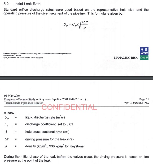
I invite readers to check my math here (I haven’t had breakfast yet), but by my calculations on this formula, a dime-sized hole (0.000252 sq. m) under standard operating pressure (9,930 kPa) would leak just seven cubic centimeters of oil per second, or a touch more than a quarter barrel or eleven gallons per minute, or sixteen barrels per hour. At full pressure, a dime-sized hole would need 13 days to leak the reported 5,000 barrels.
Maybe Canadian math varies bigly.
Thanks for the info. I had no idea where to look for scientific leak formation when the real game is spill.
Dang, according to wiki-diff I just may have to apologize to someone for calling a leak-as defined by wiki-diff-as a spill.
http://wikidiff.com/spill/leak
Why we continue to allow the destruction of our lands. http://www.mypalmbeachpost.com/news/new-russian-yacht-docks-port-will-putin-friend-pay-trump-visit/jHOu5zlKUqMa0lMLsqzz6L/
These guys don’t even try to hide it anymore. The oil oligarchs come to port to make more expansions of their poisons with a willing accomplice. Krebs says she is all in for the trump/putin agenda. Expect more of these leaks with bigger and bigger destruction patterns for our state and the rest of the country.
There will be another Dapl proposed soon also , one would have to assume .
How do they know the amount of back pressure to that leak from the soil. There is sandy soil which is very porous which could allow the leak to let out more oil and clay would seal so the leak would be slower. So taking a math formula for how much can flow through a certain size hole if that hole is into the air, or one type soil or another is not necessarily accurate. Also, if there is sand below the amount of oil that went down to the aquafer may not be determinable. Experts want us to think they have it under control and that they know what happened, but that does not mean that they have a clue. If they guess confidently, they may put the public’s minds at rest, but when they do not let any reporters near, tells you they do not really want you to know. Do they allow the EPA anywhere near? Is anyone allowed near the site to test the soil at any depth or are they totally closing it off to everyone?